Wully Davidson: Tropical Cyclones in a Warming World
Tropical Cyclones and Climatic Factors
Tropical cyclones are the result of a number of climatic factors, but high sea surface temperatures (SSTs) are perhaps the most fundamental. It’s therefore logical that, as the seas get warmer, there will be more, and stronger, tropical cyclones. There does seem to have been an increase in the number of ‘major’ storms, throughout the world, in recent years (category 3-5), but evidence for an increase in frequency, globally, appears to be lacking. There has been an uptick in frequency in the Atlantic and east/central Pacific, but fewer storms in the western north Pacific, so no clear pattern is emerging. Climate models actually predict that the frequency of tropical storms will decrease, which seems counter intuitive, but the models have thus far failed to predict many important developments that are believed to be caused by climate change, so I wouldn’t place too much confidence in any particular prediction. Global climate is highly complex and chaotic, and climate change will always spring surprises.
Tropical Cyclones Are Storms That Form Over The Ocean
Tropical cyclones are storms that form over the ocean at 5 to 30 degrees north or south of the equator. They can’t form closer to the equator, because the Coriolis force, which starts them spinning, is too weak at less than 5 degrees north or south. SSTs of 26-27 C or higher are usually required, although they sometime form over cooler water, if upper atmospheric temperatures are unusually low, thus enhancing convection. Wind shear, Saharan dust, land interaction, and dry, sinking air can all prevent cyclogenesis, or cause storms that have formed to dissipate. In the north Atlantic and eastern Pacific, they are known as hurricanes, in the Indian Ocean and south west Pacific, they are called cyclones, and in the north west Pacific, they are known as typhoons.
Distribution of Cyclones in a Warmer World
Changes to the distribution of cyclones in a warmer world will occur as SSTs increase to the required threshold further from the equator. Places that were seldom threatened by them in the past, such as New York City, may see more of them in future. Other factors in a changing world could result in local increases, and in recent years there has been an unusually high number in the Gulf of Aden, and near Madagascar.
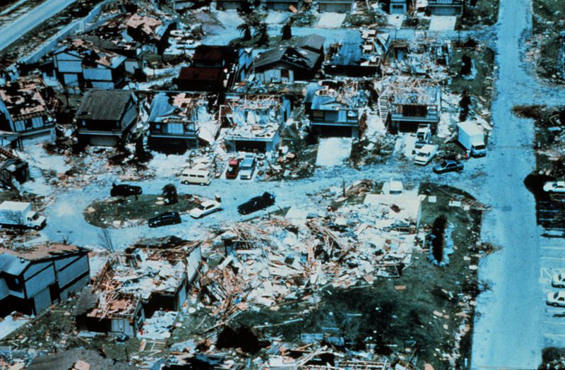
(Aftermath of Hurricane Andrew Miami- NOAA / National Weather Service, Public domain, via Wikimedia Commons)
Stalled Hurricanes, Rainfall and Flooding
A particularly dangerous recent development in the Atlantic, has been a tendency for hurricanes to stall in the same place for a much longer period of time than usual. Hurricane force winds of much longer duration will obviously cause much more damage, and the greatly increased rainfall from a stalled system will cause much worse flooding. In September 2019, hurricane Dorian, a category 5 storm with winds of 185 mph became the strongest hurricane on record to hit the Bahamas. It stalled for two days, causing $3.4 billion in damage and an estimated death toll of more than 600. In August 2017, category 3 hurricane Harvey stalled over Texas for four days, dropping a widespread 40 inches of rain and a record five feet of rain near Houston. Hundreds of thousands of homes were inundated, 106 people killed, and the cost of the damage tied with hurricane Katrina at an eye watering $125 billion. However, the greatest devastation caused by a stalled hurricane was in October 1998, when hurricane Mitch parked itself over central America from Oct 29 to Nov 3. It had been a 180 mph category 5 out at sea, weakening to a tropical storm over land. The mountainous terrain funneled the estimated 75 inches of rain down steep ravines, and the estimated loss of life was more than 22,000. It was the worst Atlantic hurricane disaster since the ‘Great Hurricane’ of 1780. The president of Honduras said that Mitch had cost his country 50 years of economic development.
Atlantic Hurricanes
It can’t yet be said with certainty that climate change is causing the forward motion of Atlantic hurricanes to slow down, and thus cause much more damage where they stall. On the face of it, it does seem a rather odd development. However, the Arctic has warmed more than neighbouring temperate latitudes, which has resulted a weakening of the polar jet stream. Its giant ‘loops’, known as ‘Rossby waves’, have become even larger, and are plunging further south. At the same time, their west to east movement has slowed down to a crawl. The polar jet is responsible for much of the weather in the northern hemisphere, and the recent changes in its activity have resulted in ‘stuck’ weather patterns, persisting for much longer than normal. This has resulted in abnormally long cold and warm spells, such as record warm summers and wildfires in Siberia, record drought in south west US, and the this year’s coldest April in the UK since 1922. If the recent tendency for Atlantic hurricanes to stall is a real phenomenon, and not due to random chance, then it is probably changes to the polar jet stream that is causing it.
Sea level rise will also add to the damage potential of tropical storms by making storm surge worse. Of the three elements of hurricane damage – wind speed, rainfall and marine storm surge, it is the storm surge which usually causes the worst damage. There may also be an increase in the size of the systems. This is an underrated component. The damage potential of a cyclone is not only dependent on its wind speed, but also on its size. Hurricane Sandy was only a borderline tropical storm/category 1 storm at landfall in New York in October 2012. But, it was the largest Atlantic cyclone on record, spanning 1,150 miles in diameter. Because of its immense size, it was the 5th costliest US storm on record, at $68.7 billion. It’s not yet certain that global warming will result in larger systems, but scientific opinion leans towards that.
The official Atlantic hurricane season begins on June 1st, and continues to November 30th. The eastern Pacific season begins on May 15th, and there have been suggestions recently that the Atlantic season should start at the same time as the eastern Pacific season, because the first named storm of the season has been getting earlier.
First named storm in the Atlantic:
2020 Arthur May 16-19 60 mph
2019 Andrea May 20-21 40 mph
2018 Alberto May 25-31 65 mph
2017 Arlene Apr 19-21 50 mph
2016 Alex Jan 12-15 85 mph
This is strong evidence that global warming will result in a longer hurricane season. We live in interesting times.
W. Davidson, May, 2021
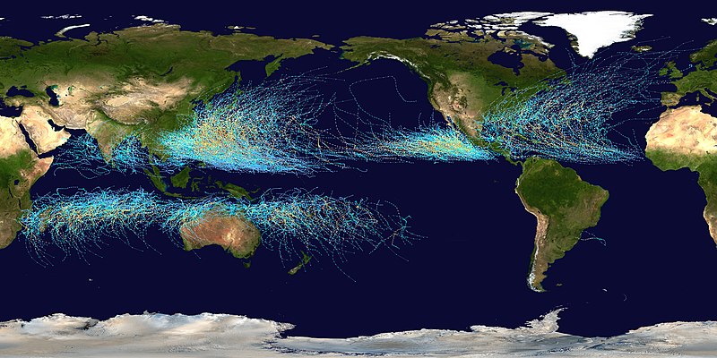
Image attribution: Background image: NASAthis version: Nilfanion, Public domain, via Wikimedia Commons
This section: Science: Climate Change and Other Topics
Filed under: Science: Climate Change and Other Topics
Prevous page or post | Next page or post
Written by : Pat Byrne
Publisher of Pat's Guide to Glasgow West End; the community guide to the West End of Glasgow. Fiction and non-fiction writer.
Related Pages
- W. Davidson Climate Change Blog: Super El Nino on the Way?
- A Monster Called Milton
- Wullie Davidson: Record Global Temperature in 2023
- Global Climate Change in September and October 2023
- Wullie Davidson: June until August, 2023 – Climate Events
- Wullie Davidson: Climate Change Blog – Global Warming Just Got Worse
- Wullie Davidson Climate Change Blog: Global Ocean Temperature Reaches Record High – El Nino Brewing Up
- Wullie Davidson on Climate Change – European Winter Drought and More
- Wullie Davidson: Extreme Weather Events of 2022
- Wullie Davidson’s Blog: Avian Influenza
- Melting glaciers – the ice gives up its secrets
- Hurricane Season 2022 – Wullie Davidson
- Wully Davidson: Developments in Global Climate Change 2022
- Wullie Davidson’s Blog: Extreme Global Weather Events of 2021
- Wullie Davidson’s Blog: COP26
- Glasgow Connects, Glasgow Science Festival 2021
- Wully Davidson: Tropical Cyclones in a Warming World
- Uptick in Global Volcanic Activity: Climate Change – Wully Davidson
- Some of the Effects of Global Warming
- Global Warming