Wullie Davidson: Extreme Weather Events of 2022

La Nina
The three year La Nina event in the Pacific continues to have a moderating influence on global temperatures, with 2022 being the sixth warmest year, globally, since reliable record keeping began in 1880. According to NASA, it was 0.89 C above the 1951-80 average. 2020 was the warmest year on record, at +1.02 C.
A fourth La Nina year would be unprecedented since monitoring began, but predictions are for a return to ENSO neutral conditions by the spring, with a 50% chance of El Nino returning in the autumn. ENSO events (El Nino and La Nina) vary in intensity and duration. Anomalously warm years usually occur the year following El Nino years, and even a moderately intense one starting in the autumn would probably be followed by a record breaking warm year in 2024. A strong one would take us into uncharted territory, with some scientists predicting that an intense El Nino could result in the 2020 global temperature record being exceeded by as much as 0.3 C. However, predicting future ENSO states is an inexact science, and scientists are often proved wrong.
Current Climate Anomalies
Record Rain in New Zealand
Currently, there are two weather related events making the headlines. Torrential rain has flooded much of North Island, New Zealand, but particularly Auckland, with 249 mm (9.8 in) recently falling there in 24 hours. This has greatly exceeded the previous 24 hour record of 161 mm (6.3 in). When weather records are broken, it’s usually by a small margin, not by 55%, and is yet another example of climate change amplifying extreme weather. At the time of writing (Jan 30), another 80 to 120 mm (3.15 to 4.7 in) is predicted to fall over the next few days.
Antarctic Sea Ice
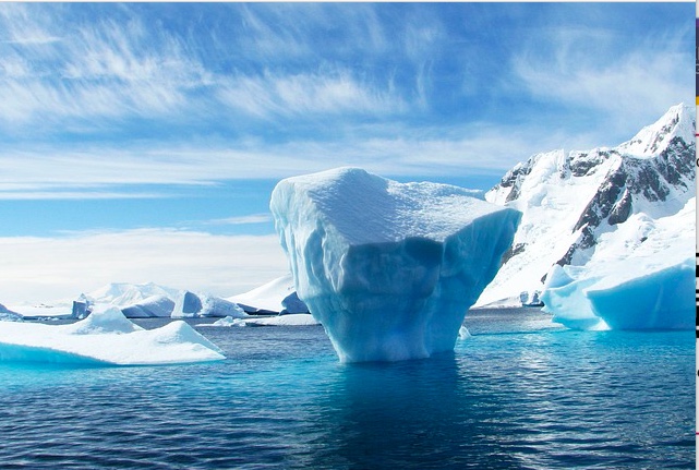
Sea ice extent around Antarctica tends to fluctuate between extremes. In 2014, it reached a record high, and scientists still aren’t sure why. After that, it began decreasing precipitously, and fell to a record low extent in February, last year. With still two weeks of the 2023 melt season left, a new record low has already been set, by a large margin. Satellite monitoring of Antarctic and Arctic ice began 45 years ago.
Extreme Weather Events Around the World, 2022
Heat Wave in China
2022 was the warmest year on record in 28 countries, including the UK, China, France, Germany, Ireland, Italy, New Zealand, Portugal and Spain. From June until the end of August, China baked under record temperatures, 45 C (113 F) being the highest recorded. Because of its duration and areal extent, it was described by weather historian, Maximiliano Herrera, as ‘the greatest heat wave in recorded global history’. Hundreds of weather stations set all time records. There was severe drought, with crop failures, and many rivers drying up completely. The level of the Yangtze river fell by 6 metres. The reduction in hydropower and increased demand for electricity resulted in widespread power failures. While the northern and central regions baked in the heat, southern China had record rainfall and flooding.
European Heat Wave

Image by Myriams-Fotos from Pixabay
From June to August, an extreme heat wave afflicted Europe, stretching from Spain to Scandinavia and western Turkey. The highest temperature recorded was in Portugal on July 14, at 47 C (116.6 F). More than 26,000 excess deaths were attributed to the heat. It was the worst year for drought in Europe for at least 500 years, and the river Rhine’s water level fell to a record low. It is significant, in the context of climate change, that the previous record low level for the Rhine was as recently as 2018. The cost of transporting goods by river barge rose sharply, as boats could only load 30% of their usual cargo.
In the UK, a new national temperature record of 40.3 C (104.5 F) was set. This obliterated the previous record of 38.7 C (101.7 F), set in 2019. Again,it is worth reflecting on how quickly new records are being set. Several counties had their driest July since records began in 1836. Scientists predict that changes to the jet stream resulting from climate change, will cause extreme heat waves with increasing frequency in Europe.
Pakistan Floods
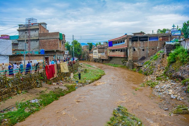
Image by Kamran Khan from Pixabay
Global temperature has increased by 1.2 C since the pre-industrial era, with the ocean surface temperature averaging +0.7 C. However, the Indian Ocean has warmed by 1.0 C, resulting in more intense monsoon rains. In 2022, Pakistan was devastated by the worst flooding in its history, due mainly to much heavier monsoon rains. Other contributory factors included a severe heat wave which created an intense area of low pressure, sucking in air from the ocean. The heat wave also caused extreme melting of mountain glaciers which exacerbated the flooding. Deforestation also contributed to the flooding, by increasing the runoff from higher ground.
The floods killed 1,739 people and more than a million head of livestock, causing more than $30 billion in damages and economic losses. More than 2.1 million people were made homeless, and the total area of standing floodwater peaked at 32,800 square miles. Pakistan contributes less than 1% of greenhouse gases, but is one of the countries most vulnerable to climate change.
Hurricane Ian
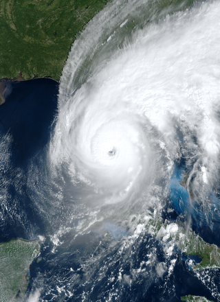
https://registry.opendata.aws/noaa-goes/
Author NOAA
Despite pre season predictionss of an active season, the 2022 Atlantic hurricane season turned out to be near average for the number of storms it produced. But, Hurricane Ian was anything but average. Ian began life as a tropical wave moving off the coast of west Africa on September 14. It remained disorganised as it traversed the Atlantic, into the Caribbean Sea, becoming a tropical storm with 40 mph winds on September 24. On September 27, a rapidly intensifying Ian made landfall in western Cuba as a high end category 3 major hurricane, with sustained winds of 125 mph. On September 28, Ian reached peak intensity, with sustained winds of 155 mph, just 2 mph below the threshold of a maximum category 5 hurricane, and gusting up to 215 mph. It made landfall in south west Florida as a strong category 4 hurricane, with sustained 150 mph winds.
Ian was the third costliest tropical cyclone on record, and the costliest in Florida’s history. It caused $113 billion in damages, compared to the $125 billion estimated for both Katrina (2005) and Harvey (2017). There were a total of 159 fatalities, 148 of them in Florida. Most of the damage was caused by a marine storm surge of 10-15 ft (3.0 – 4.6 m). Ian weakened to a tropical storm as it crossed Florida, but reintensified to a category 1 hurricane when it emerged back into the Atlantic, finally making a third landfall in South Carolina as an 85 mph category 1 hurricane.
Wullie Davidson, January, 2023
This section: COP26 Glasgow, Climate Change, Save the Planet, Science, Biodiversity Events, Pat's Home Page Blog, Science: Climate Change and Other Topics
Filed under: COP26 Glasgow, Climate Change, Save the Planet, Science, Biodiversity Events, Pat's Home Page Blog, Science: Climate Change and Other Topics
Prevous page or post | Next page or post
Written by : Pat Byrne
Publisher of Pat's Guide to Glasgow West End; the community guide to the West End of Glasgow. Fiction and non-fiction writer.
Related Pages
- tell it slant at Locavore
- ‘Premature’: First clip released from brand new Scottish rom-com
- Commonwealth Community Festival
- Alasdair Gray Archive – Matthew Arthur Williams: Holding Ground
- Wullie Davidson Bus Pass Rambles: Walk to Steall Falls in Glen Nevis
- Going for Gold: Young Talent 2026 at ProjectAbility
- Arepas for Venezuela – Fundraiser
- Take 2: Muppet Treasure Island at GFT
- Wildlife Watch at The Saltings: An Introduction to Wildlife Recording
- Exhibition Faifley Art Group
- Scottish Writers Centre Speakeasy The Griffin
- Watershed Festival at The Briggait
- Gaggle
- Glasgow Merchant City Festival 2026
- Partick Thistle F.C. Exhibition, Maryhill Burgh Halls
- Chicago! The Drag Along at OranMor
- Helen Rose Outdoor Diary: Elie Chain Walk.
- The Effect by Lucy Prebble at Cottiers
- Dementia Heroes – Family Carers Day
- Take 2: Arco (Dubbed) at GFT