Wullie Davidson on Climate Change – European Winter Drought and More
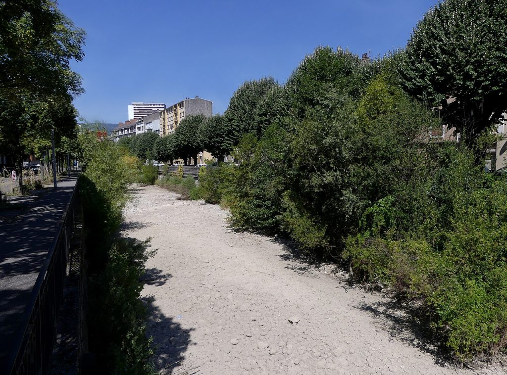
European Winter Drought
In the summer of 2022, Europe experienced its worst drought for at least 500 years. The World Weather Attribution service has stated that northern hemisphere drought was at least 20 times more likely because of climate change, and that such extremes would become more common as the world warms. In more ‘normal’ times there might be a period of several decades between record temperatures, droughts and floods. But, with changes to the polar jet stream caused by Arctic warming resulting in it becoming ‘stuck’ in place for longer periods, extreme weather events are becoming more intense and longer lasting and records are being broken within a year or two of the previous record.
Usually, when Europe has an abnormally dry summer, winter rain and snowfall will recharge reservoirs, rivers and groundwater levels. Many regions, such as Italy’s Po valley, are dependent on Alpine snow melting slowly as the year progresses. This keeps the water level high enough in the Po river to allow irrigation of the valley, which is known as Italy’s breadbasket. However, this winter was Europe’s second warmest on record. Significantly, 2019-20 was the warmest. It was also an unusually dry winter. Across western Europe, dried up river beds and shrunken lakes – usually only seen in the height of a particularly dry summer – are currently a common sight. France has had its driest winter for 64 years, Rhine river barges can only sail half laden and Barcelona has stopped watering its 175 parks. The Alpine snowpack is currently around a third of the winter norm and the snowpack in the Pyrenees is also at a record low.
This sets the scene for an even more devastating summer drought in Europe than last summer, but the weather patterns could yet change. In the summer of 2021, Europe was hit by catastrophic floods which caused the deaths of 243 people. In Belgium, 11 inches of rain fell in just 48 hours. Many areas would not have seen rainfall of this magnitude for 1,000 years. The culprit was a stuck jet stream, which trapped a low pressure system in the same place for two days. So, although the scene is set for devastating drought, it’s far from certain that it will happen. The three year La Nina event in the tropical Pacific is now officially over, and we are now in an ENSO neutral phase. That is likely to have a subtle effect on global weather.
Drought in Argentina and the Horn of Africa
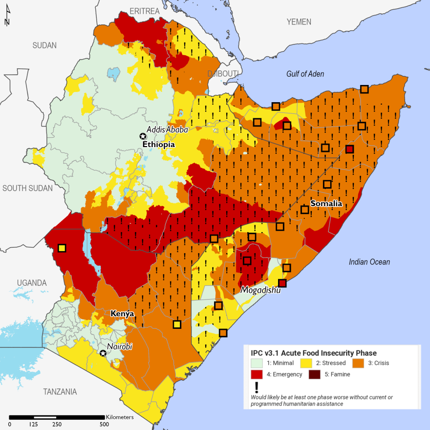
FEWS, Public domain, via Wikimedia Commons
Argentina is currently experiencing its worst drought and hottest summer since record keeping began 60 years ago. Farmers are facing losses of $14 billion and a shortfall of 50 million tons of soy, maize and wheat. The drought has been ongoing since May 2022. Argentina is the world’s biggest producer of soy, but it is currently predicted to be the worst soy harvest since the turn of the century, when there was only half the acreage planted, compared with today. Perversely, the neighbouring region of Sao Paulo state in southeast Brazil saw an incredible record 26 inches of rain in the 24 hours to 19 February. Brazilian meteorologists described it as “an unprecedented extreme weather event”. The previous record was in 2022, when 21 inches fell.
The unrelenting drought in the Horn of Africa (Kenya, Ethiopia and Somalia) began with well below average rainfall in the October to December 2020 rainy season. There are two rainy periods each year when planting takes place, and all since then have failed to produce enough rain for harvests. The persistent La Nina is believed to have contributed to the drought. With the return to ENSO neutral conditions and a predicted 62% chance of El Nino returning in the autumn, the October to December rains may return to something like normal, but the March to May planting season is expected to remain in drought. Some 23 million people are currently suffering from malnutrition. 11 million head of livestock have perished and families have no resources left to replace them, or even to buy seeds for planting, even if the rains do return.
Record Breaking Tropical Cyclones in the Southern Hemisphere
Cyclone Gabrielle
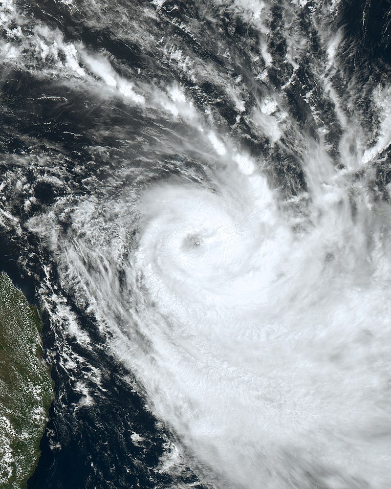
Japan Meteorological Agency, CC BY 4.0 <https://creativecommons.org/licenses/by/4.0>, via Wikimedia Commons
Tropical Cyclone Gabrielle was first noted on February 6 as a developing tropical low in the Pacific Ocean, near the Solomon Islands. It peaked as a severe tropical cyclone category 3 storm with winds of 105 mph, and then weakened back to a subtropical depression as it approached New Zealand’s North Island on February 12, after causing damage in Vanuatu and Norfolk Island. The winds were still strong enough to down power lines, bring down trees, and cause structural damage to buildings. 225,000 homes were left without electricity. But, it was the rainfall which did the most damage, with one weather station recording 19.2 inches of rain.
North Island had been experiencing what was being described as the worst ever summer, with heavy rain falling throughout January. This culminated in an exceptional rain event on January 27 when an entire summer’s worth of rain fell in one day, with Auckland bearing the brunt. It was estimated as a 1 in 200 year event. So, when Gabrielle arrived, the soils were saturated and steep hillsides dangerously primed for landslides. Hillsides collapsed, burying roads and houses, bridges were washed away, and vineyards ruined by silt. 11 people were killed, most of them in the wine producing area of Hawke’s Bay. A national state of emergency was declared, for only the third time in New Zealand’s history. Gabrielle was the costliest southern hemisphere cyclone on record, with the damage in New Zealand estimated at US $8.1 billion, a huge amount for a country with a population of just 5 million people.
Cyclone Freddy

Tropical Cyclone Freddy is probably the most oddball tropical cyclone that has ever been seen. Freddy began life in the Timor Sea between Australia and Indonesia on February 6. It became one of only three cyclones on record to travel from one side of the Indian Ocean to the other, attaining category 5 status with 165 mph winds en route, and made landfall on Madagascar’s east coast as a category 3 storm with 115 mph winds on February 21. After travelling across the island, it emerged into the Mozambique Channel, and made its first landfall in Mozambique on February 24. It then reemerged into the channel and made a second landfall in Madagascar in the southwest of the island. Having made two landfalls in Madagascar, Freddy decided it would go for the full house and reemerged back into the channel, making a second landfall in Mozambique. This time, it went further inland and became the first tropical cyclone on record to visit landlocked Malawi, still packing 50 mph winds. At the time of writing (March 13), it is meandering in that area, and several meteorological agencies are predicting that it will reeemerge into the channel for a fourth time.
Records broken by Freddy
1) Freddy is the longest lived tropical cyclone on record, having been over the ocean as a named storm for 36 days.
2) Accumulated cyclone energy (ACE) is the estimate of a cyclone’s energy output during its lifetime. It is derived from the lifetime of the cyclone over water multiplied by its maximum speed during six hour windows within its lifetime. Freddy has now surpassed the ACE record held by hurricane Ioke of 2006 and has generated more ACE on its own than the total ACE generated by all the named storms in an average Atlantic hurricane season.
3) Rapid intensification (RI) is defined as an increase in wind speed of at least 35 mph in 24 hours. Prior to Freddy, three storms jointly held the record of 4 periods of RI. On March 11, Freddy completed an astounding SEVENTH round of RI.
If Freddy does emerge back into the Mozambique Channel, its duration and ACE records will increase.
Severe California Drought Ends but the Flood Begins
.jpg)
Flooded Underpass San Mateo btwashburn, CC BY 2.0 <https://creativecommons.org/licenses/by/2.0>, via Wikimedia Commons
For the past three years California has endured an intense drought that has caused rivers to dry up, reservoir levels to fall to unprecedented lows and wildfires to rage out of control in the abnormally dry conditions. Then, in November, a parade of ‘atmospheric rivers’ began, bringing welcome relief from the drought. Known to Californians as the ‘pineapple express’, because it originates near Hawaii, these rivers of moisture laden air are brought across the ocean by the jet stream. Thus far, there have been eleven of them since November, with more expected. Reservoirs are now full, and the snowpack in the Sierra Nevada is currently at 243% of normal and more is expected. The record of 668 inches (55.7 ft) could be broken. However, they also bring flooding, and on March 9 governor Gavin Newsom declared a state of emergency for 34 counties and most of California’s 39 million residents were under a weather warning. Californians are now dealing with impassable roads, overflowing rivers, inundated neighbourhoods and breached levees. President Biden pledged federal funds to help deal with the crisis. A National Weather Service spokesman warned that the incoming stream of moisture, bringing up to 15 inches of rain, was “unprecedented in several decades, perhaps to as far back as 1969”. Extreme avalanche warnings were also issued, ‘extreme’ being the highest level of avalanche danger in California.
Climatologists have predicted that both droughts and flooding rains in California will increase in intensity, duration and frequency as the world warms. With increased evaporation from the ocean, a greater capacity for a warmer atmosphere to hold moisture, and the jet stream now plunging further south and remaining in situ for much longer periods than in the past, the stage seems set for historic flood events in the state. The best known historic flood was the Great Flood of 1861-62. During that winter, a six week onslaught of at least ten powerful atmospheric rivers of subtropical moisture dumped 10 feet of torrential rains in the valleys and an abnormally large amount of snow in the Sierra Nevada mountains. When an unusually warm rain event in January fell on the snowpack, it melted and inundated more than 5,000 square miles of the Central Valley to a depth of 30 feet, and the state was bankrupted. More than 4,000 people lost their lives, which was about 1% of the population.
This was not a one off freak event. Sediment analysis reveals that at least six storms similar to, or even more severe than the Great Flood of 1861-62 have occurred in California in the past 2,000 years. These occurred in AD 212, 440, 603, 1029, 1418 and 1605. The 1605 storm appears to have been the worst, with at least a 50% greater volume of water than any of the others. It seems likely that global warming will increase the chances of such megafloods happening in the future. A 2011 study called the ARkStorm scenario involved 117 scientists led by the US Geological Survey. ‘AR’ stands for ‘atmospheric river’ and ‘k’ for once in a thousand years. The storm modeled could flood up to 25% of all buildings in California, force the evacuation of 1.5 million people, and cost approximately $1.7 trillion in damages and economic losses, equivalent to about 14 hurricane Katrinas. A 2022 study estimated that, relative to a century ago, climate change has already doubled the risk of a California megaflood, and more than tripled the risk of a trillion dollar disaster. However, scientists tend to be conservative with their predictions, and the extreme weather events that we are witnessing throughout the world today, were not predicted to occur for decades into the future. Many extreme weather events that previously were expected to occur less than once in 100 years are now occurring regularly. Moreover, the megaflood predictions do not take into account the changes that have occurred with the jet stream, which have the potential to greatly amplify the chances of such a megaflood event. We live in interesting times.
Wullie Davidson, March, 2023
This section: COP26 Glasgow, Climate Change, Save the Planet, Science, Biodiversity Events, Pat's Home Page Blog, Science: Climate Change and Other Topics
Filed under: COP26 Glasgow, Climate Change, Save the Planet, Science, Biodiversity Events, Pat's Home Page Blog, Science: Climate Change and Other Topics
Prevous page or post | Next page or post
Written by : Pat Byrne
Publisher of Pat's Guide to Glasgow West End; the community guide to the West End of Glasgow. Fiction and non-fiction writer.
Related Pages
- tell it slant at Locavore
- ‘Premature’: First clip released from brand new Scottish rom-com
- Commonwealth Community Festival
- Alasdair Gray Archive – Matthew Arthur Williams: Holding Ground
- Wullie Davidson Bus Pass Rambles: Walk to Steall Falls in Glen Nevis
- Going for Gold: Young Talent 2026 at ProjectAbility
- Arepas for Venezuela – Fundraiser
- Take 2: Muppet Treasure Island at GFT
- Wildlife Watch at The Saltings: An Introduction to Wildlife Recording
- Exhibition Faifley Art Group
- Scottish Writers Centre Speakeasy The Griffin
- Watershed Festival at The Briggait
- Gaggle
- Glasgow Merchant City Festival 2026
- Partick Thistle F.C. Exhibition, Maryhill Burgh Halls
- Chicago! The Drag Along at OranMor
- Helen Rose Outdoor Diary: Elie Chain Walk.
- The Effect by Lucy Prebble at Cottiers
- Dementia Heroes – Family Carers Day
- Take 2: Arco (Dubbed) at GFT