A Monster Called Milton
Hurricane Milton will be visiting Florida on Thursday morning, and is likely to be catastrophic, particularly if it goes into Tampa Bay, although current predictions are that it will go south of there. It’ll still be bad, though.
A Monster Called Milton
Tropical Cyclones in a Warmer World
It has long been predicted that global warming would result in more, and stronger, tropical cyclones. They are fueled by the evaporation of warm surface water, and the release of latent heat energy as this water condenses, so it’s a no brainer that a warming sea surface would result in an increase in frequency and strength. Strangely, the evidence for this remains weak in the Pacific and Indian oceans, but there has been increased hurricane activity in the North Atlantic in recent years. The first named storm now very often occurs before the official start of the hurricane season, there are an increasing number of storms, and a disproportionate increase in very strong hurricanes. 2020 holds the record for the number of named storms (30), 2021 is third with 21, and 2023 joint fourth with 20. There has also been an increase in instances of ‘rapid intensification’ of storms, defined as an increase in wind speed of at least 35 mph in a 24 hour period.
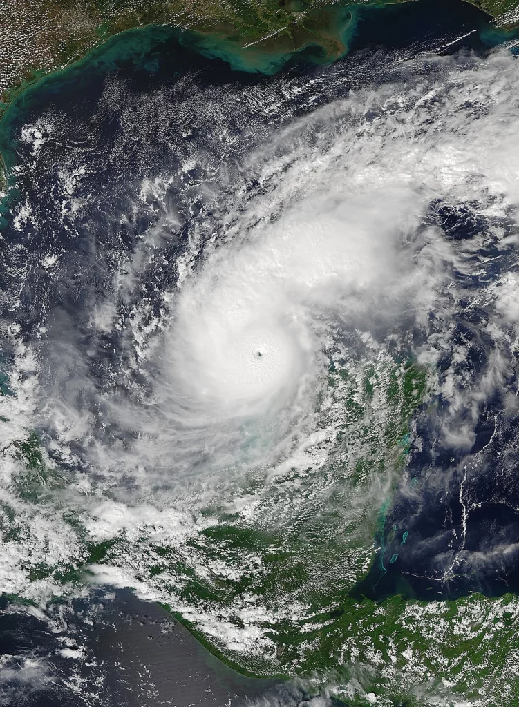
Hurricane Beryl
ABI imagery from NOAA’s GOES-16 Satellite, Public domain, via Wikimedia Commons
The North Atlantic hurricane season begins officially on June 1 and ends on November 30. The peak of the season is September 10, after which activity gradually decreases, but there have been many major hurricanes well into October. Hurricane Beryl became a category 5 storm (>155 mph) on July 2, the earliest ever category 5 storm in the Atlantic, and only the second recorded in July. Its peak winds of 165 mph made it the strongest July storm on record in the Atlantic.
Beryl developed from a tropical wave that left the coast of Africa on June 25, and reached the Lesser Antilles islands in the eastern Caribbean on July 1 as a 150 mph hurricane. Grenada and St. Vincent sustained $430 million and $300 million of damage respectively, with a total of 14 deaths.It then traversed the Caribbean, crossed Mexico’s Yucatan peninsula, and headed across the Gulf of Mexico to make a third landfall in Texas as a 80 mph category 1 hurricane. The US sustained $6 billion in damage and there were 45 deaths.
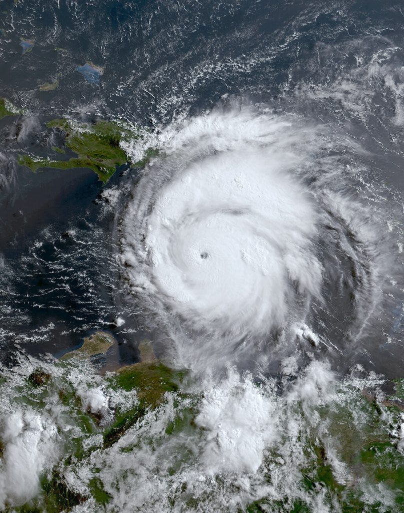
Hurricane Helene
ABI imagery from NOAA’S GOES-16 Satellite, Public domain, via Wikimedia Commons
On September 26, hurricane Helene made landfall in the sparsely populated ‘Big Bend’ area of Florida as a 140 mph category 4 hurricane. It travelled inland and stalled, dropping more than 30 inches of rain in the mountains of North Carolina, where communities and roads were washed away in the ensuing flash floods.
Relief efforts are ongoing, but have been severely hampered by the fact that a great many roads no longer exist. Mules have had to be used to transport supplies. Helene is the deadliest hurricane in mainland US since Katrina in 2005. Currently, the death toll is around 240, with more than 285 still missing. Damage has been estimated at $38.5 billion, but this figure is likely to rise.
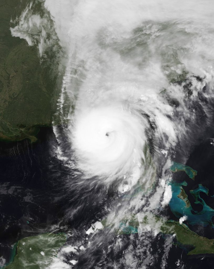
Hurricane Milton
Hurricane Milton originated off the coast of Mexico on October 5 and underwent explosive rapid intensification to a category 5 hurricane with 180 mph winds by October 7. This was the fastest intensification from an unnamed tropical depression to a category 5 hurricane ever witnessed in the Atlantic, at 49 hours. Its minimum pressure was 897 mb, the fifth most intense on record for the Atlantic. In the region where Milton intensified from a category 4 to a category 5, sea surface temperatures were 1.8 C above average. It then had an ‘eyewall replacement cycle’ which caused it to drop back to 145 mph, while its eye and wind field expanded. By Wednesday morning, it had strengthened back up to a category 5 160 mph storm.
Milton will make landfall in Florida around 6 am Thursday, UK time. It is expected to weaken down to a 130 mph category 3 storm, just prior to landfall, which will reduce wind damage, but it is expected to grow in size, which will make the destructive effects of storm surge worse. The reduction in wind speed will have little effect on the marine storm surge. The National Hurricane Center (NHC) predicts that there will be a 15 foot storm surge along a 70 mile stretch of one of the most densely populated sections of the US coast, and up to 10 feet for an additional 50 mile stretch. Most of the damage from hurricanes are a result of marine storm surge, with rainfall flooding coming second, although it varies from storm to storm. Most of the damage from Helene was caused by rainfall flooding.
Tampa Bay
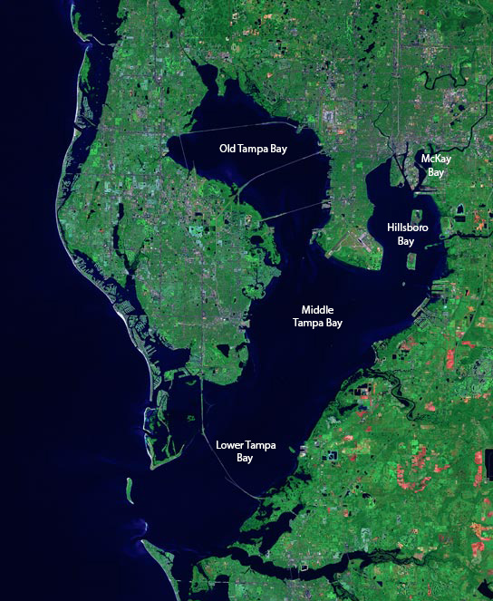
erraprints.com, CC BY 2.5 <https://creativecommons.org/licenses/by/2.5>, via Wikimedia Commons
The effect of this marine storm surge is likely to be catastrophic, all the more so if it goes into Tampa Bay, or makes landfall just north of there. The bay acts as a funnel, amplifying the storm surge, and many buildings are just a few feet above sea level. This makes Tampa the most vulnerable US city to a hurricane. The NHC is currently predicting landfall south of Tampa Bay, but this could change. South of Tampa Bay would be a very good result, as the wind into the bay would then be coming from the land, pushing water out of the bay. If it landfalls to the north of the bay, this would be almost as bad as the storm going right into the bay, and hundreds of thousands of homes could be underwater. The last time a hurricane went into Tampa Bay was on October 26, 1921, when a category 4 storm struck. Today, there is 8 times the population there was back then.
Hopefully, Milton will make landfall south of Tampa Bay, but wherever it goes, there will be a catastrophe, purely because of the high population density of the region. After landfall, Milton will weaken and cross the Florida peninsula as a 80 mph category 1 hurricane, hitting Orlando in the process. Here, the main effects will be power outages. It will emerge into the Atlantic as a category 1 storm, and dissipate south of Bermuda.
Home Insurance
Milton may be the nail in the coffin for Florida home insurance. Rates have skyrocketed in recent years, and have become unaffordable for many. Insurance is required for those with a mortgage, and there may be an exodus of people from the state. Some insurers will simply withdraw from the market. Presumably, the federal government will step in, but those paying the market rate will disapprove of others being subsidised.
This section: COP26 Glasgow, Climate Change, Save the Planet, Science, Biodiversity Events, Science: Climate Change and Other Topics
Filed under: COP26 Glasgow, Climate Change, Save the Planet, Science, Biodiversity Events, Science: Climate Change and Other Topics
Prevous page or post | Next page or post
Written by : Pat Byrne
Publisher of Pat's Guide to Glasgow West End; the community guide to the West End of Glasgow. Fiction and non-fiction writer.
Related Pages
- W. Davidson Climate Change Blog: Super El Nino on the Way?
- Glasgow Seed Library – Pollination: Seed to Seed Workshop
- A Monster Called Milton
- Tree Identification, Training and Guides Glasgow
- Wullie Davidson: Record Global Temperature in 2023
- Global Climate Change in September and October 2023
- Wullie Davidson: June until August, 2023 – Climate Events
- Glasgow National Park City Event
- Wullie Davidson: Climate Change Blog – Global Warming Just Got Worse
- How To Save Our Planet – The Children’s Wood
- World Environment Day 2023 – Partick
- SCCAN: The Oil Machine – can we be break the addiction
- Wullie Davidson Climate Change Blog: Global Ocean Temperature Reaches Record High – El Nino Brewing Up
- SCCAN. Member Networking Meeting: Community Food
- Sharing City Community Assembly
- Wullie Davidson on Climate Change – European Winter Drought and More
- Wullie Davidson: Extreme Weather Events of 2022
- Wullie Davidson’s Blog: Avian Influenza
- Climate Crisis Protest in Lützerath
- Interfaith Glasgow: Climate Justice is Gender Justice