


Ben Alder August 2005
Helen Rose Hill Diary
 Although I am struggling through these Munros, many of them are just hills to tick without any outstanding features but one which stands out as everyone seems to have heard of is Ben Alder. It is mostly renowned for remoteness and sheer bulk. However, it is also reputed to be where Bonnie Prince Charlie?s treasure is buried. I suppose I should have taken a metal detector to sweep the mountain but it would have been extra weight to carry on the long walk and climb to it!
Ben Alder and the adjacent Munro Ben Bheoil are located on the privately owned Ben Alder Estate. In Scotland there is a right of way over private land but with certain restrictions. Often during the deer stalking and shooting season, access will be denied to certain areas but alternative routes suggested. However, we walked to these mountains in June so no restrictions applied.
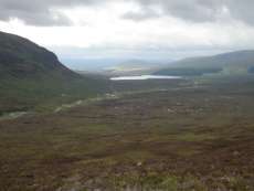
Ben Alder is a big walk whichever way you do it, camping or cycling and walking. Walking from Dalwhinnie and return would be around 25 miles (40 kilometres) and about 4,000 feet of ascent, really too much for one day. Walking into Culra Bothy one day and climbing the next day is one option but we chose the cycle and walk option. We stayed in the Pottery Bunkhouse at Laggan only 15 minutes drive into Dalwhinnie and made an early start. From Dalwhinnie, we crossed the railway and started the cycle on a good private road through the Ben Alder Estate along Loch Ericht in reasonably good weather but we could see the mountains ahead in a heavy mist. The road was undulating and required us to dismount and push the bikes up the short hilly sections to save our legs for the mountain climb.
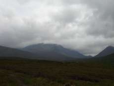
 After five miles we reached a small bridge and followed a flat track towards Culra Bothy passing Loch Pattack. At the bothy, it was tea break time by the river where many were camping out or staying in the bothy. The paths towards Ben Alder were good starting along the river and as we gained height the terrain became more rocky. There was a choice of a shorter sharper scramble or a longer route with easier scrambles. Given the severity of this walk, we opted for the easier scramble and made our way towards the summit plateau. We were now in the mist although it was warm and humid and it was difficult finding the trig point but the use of a GPS makes this much easier.
After lunch without any views inside a cloud, we descended to the col for the climb to Ben Bheoil but this was tricky navigation without any paths. As usual, Tom and Stephen were excellent on the navigation and we reached the top. By this time the mist had cleared and we had good views all around although the top of Ben Alder remained in a mist all day. I have seen it previously from other mountains around the area.
 The descent was down through the corrie back to the river to pick up the path to Culra Bothy where the horses were hanging around looking for food. These horses are used for carrying down the deer in the stalking season so were effectively on holiday!
It was a long cycle ride round back to Dalwhinnie and we reached the bunkhouse at 10pm, a long day but an achievement as a mountain I had always wanted to climb. Noreen?s Irish Stew that she had prepared and brought with her was eagerly eaten and appreciated by us.
Although this is supposed to be a very remote mountain, it was very busy with walkers as it is so popular so I did not get the feeling of remoteness. By contrast, the following day we climbed the very accessible Ben Teallach in ?Monarch of the Glen? country which is at the road but we did not meet any other walkers making it feel more remote!
 I was impressed by the investment and management of the Ben Alder estate which is well maintained and good paths and tracks provided.
Coming attractions; Arran again, Cairngorms and Glen Affric again.
Contact me at helenrose52@hotmail.com
Thanks to Frances Rickus for the photos
Comments are now closed on this page
BECOME A MEMBER!
WHAT'S NEW.

Hillwalking Diary Archive
- Forth and Clyde Canal - 17th January, 2013
- Buttermere - 10th January, 2013.
- Barga, Tuscany - September, 2012
- West Highland Way - August, 2012
- Berwick on Tweed June 2012
- Malham, Yorkshire Dales May 2012
- Dean Castle Country Park April 2012
- Drama on the Cowal Way December 2011
- Newton Stewart November 2011
- Laggan October 2011
- Baltic September 2011
- Shetland Islands August 2011
- Falls of Glomach July 2011
- Colonsay and Oronsay June 2011
- Glencoe Celebration May 2011
- Hadrian's Wall February 2011
- Grey Mare's Tail January 2011
- Portpatrick December 2010
- Far North November 2010
- Creise and Meall a'Bhuiridh September 2010
- A Wild Weekend in Corrour! July 2010
- HW Family Walk May 2010
- Glen Finglas February 2010
- Corran and Ardgour January 2010
- Southern Outer Hebrides November 2009
- Lewis and Harris October 2009
- Magical Mull and Iona July 2009
- Easains May 2009
- Arran Again February 2009
- The Old Firm - November 2008
- Picos de Europa October 2008
- Mournes September 2008
- Far North Munros August 2008
- Greenland July 2008
- Ratagan June 2008
- Ben Dorain May 2008
- Carrbridge Weekend April 2008
- Gone to the Dogs January 2008
- Musical Legends December 2007
- Last Munro November 2007
- Bidein a'Choire Sheasgaich October 2007
- Sgurr na Ciche September 2007
- Maol Chean-dearg August 2007
- An Gearanach July 2007
- Glen Feshie June2007
- Island of Eigg April/ May 2007
- Island of Gigha March 2007
- Xmas in Perthshire February 2007
- Mullardochs, January 2007
- Altbeithe, Glen Affric December 2006
- Beinn Fhionnlaidh November 2006
- Cona Mheall October 2006
- Cairngorms Completed September 2006
- Seana Bhraigh August 2006
- Tarf Hotel Bothy July 2006
- Fisherfields June 2006
- Glen Dessary May 2006
- Serellas, Spain April 2006
- Glasgow March 2006
- New York February 2006
- Winter Dolomites January 2006
- Hong Kong December 2005
- John Buchan Way November 2005
- Navigation on Creag Pitridhs October 2005
- Fannaichs Finished September 2005
- Ben Alder August 2005
- Cuillins Completed July2005
- Meall Na Teanga, Water Aid June 2005
- Wales May 2005
- Krakow, Poland
- Glenfinnan Munros March 2005
- Monadh Liath February 2005
- Dunbar January 2005
- Loch Quoich Munros November/December 2004
- Fannaichs - October, 2004.
- Loch Goil, Beinn Lochain September 2004
- Floreana, Galapagos August 2004
- Lairig an Laoigh July 2004
- Sgurr nan Gillean June 2004
- Croagh Patrick, Ireland May 2004
- Cairngorms Revisited April 2004
- Lakes Again! March 2004
- Glencoe February 2004
- Pentlands January 2004
- Cairns December 2003
- English Lake District Return November 2003
- Last Munro October 2003.
- Hill Walking Diary: Strathfarrar - September, 2003
- Hill Walking Diary - Norway - August, 2003
- Helen Rose, Hill Diary, July 2003. Skye. - 3rd July, 2003.
- Helen Rose Hill Diary: Slioch June 2003.
- Cairngorms May 2003.
- April 2003 - Japan
- March 2003 - Ben Lomond
- February 2003: Arrochar Alps
- Hadrian's Wall - January, 2003.
- December 2002: Cycling to Linlithgow - December, 2002.
- The Lake District - November 2002.
- Hillwalking in Glen Affricc - October, 2002.
- Hillwalking Diary September 2002 - Gaick Pass
- Ben Nevis (2nd August, 2002)
- Northern Ireland (30th June 2002)
- Helen Rose in Brazil. (8th June 2002)
- Helen Rose in Braemar 4th May, 2002.
- Helen Rose's Hill Diary - April, 2002: the Island of Rum.(4th April, 2002)
- Helen Rose on her holiday - Helen Rose visit to Vienna (14th Mar. 2002)
- Helen Rose's Hillwalking Diary. Ossian (13th Feb 2002)
- Helen Rose's Hillwalking Diary, Patagonia. January, 2002
- Mull December 2001
- Helen Rose's Hill Walking Diary - November, 2001Bernese Oberland, Switzerland. (4th November, 2001)
- Helen Rose's Hillwalking Diary - Yosemite October, 2001.
- The Scottish Mountain Weather September 2001
- Andalusia August, 2001
- Ullapool Weekend July 2001
- Machu Picchu - June, 2001
- Helen Rose's Hillwalking Diary - Villarica May, 2001
- Helen Rose's Hill Walking DiaryDiabetes - April, 2001.
- Hill Scrambles March, 2001
- Everest Base Camp Feb 2001
- St Cuthbert's Way Jan 2001
- Hill climbing diary by Helen Rose, Knoydart (11/11/2000)
- Islay, Jura and Ratagan (Oct 2000)
- Iceland (20 Sept, 2000)
- Arran (22 August, 2000)
- An Teallach, July 2000
- Irish Munros, June 2000
Want to be featured or advertise on this site? Contact features or advertise.