Rivers Almond and Avon. March 2020
Helen Rose Outdoor Diary
I write this as we are in lockdown in the UK due to the Covid-19 virus pandemic. The walk I am going to describe was done a few weeks before the virus was confirmed in Scotland. Within the next few months or even longer it will be difficult to go anywhere walking and impossible to travel abroad. I have already had to cancel a trip to the US but maybe later this year…..
Lizzie Brice
The walk at the Rivers Almond and Avon was arranged by the walking club – Bearsden and Milngavie Ramblers in fine weather with a very good well informed leader Bill. Although we walked only about 6 miles, there was much to see with lots of history so we stopped regularly to hear about the historical sites. We shared cars and passed the Lizzie Brice roundabout on the way to the pre walk coffee at the J & R Veitch Garden Centre. So the question is, who was Lizzie Brice? She must have been important to have a roundabout named after her!
Lizzie Bryce lived at Raw Cottage (just northeast of the present Lizzie Brice roundabout). Her widowed daughter Elizabeth Mason had come back to stay with her, and the two women made a living by fostering pauper children from Edinburgh. Lizzie Bryce may not have been the gentlest of foster mothers. Folk memory tells that she was tall and angular and would shout at the local children and scare them. In return, they taunted her for being a witch. In the seventeenth century, old women who frightened the local community might have been accused of witchcraft and have been burned at the stake.
River Almond

The walk started in Almondell Country Park near Broxburn in East Lothian, about 12 miles from Edinburgh in the east of central Scotland. We walked over the Nasmyth Bridge built in 1800 over the River Almond and famous for its design by the painter Alexander Naismith, the noted Scottish painter, architect and landscape designer. It was built as a crossing point over the River Almond but sections of the bridge collapsed into the river in the early 1970s. Impassable for over 25 years, the bridge became one of the first Heritage Lottery Funded projects and was restored in 1997.
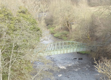
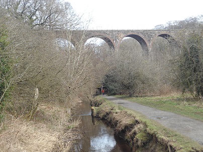
We looked down on a little metal bridge over the river and descended to it where Bill told us it was not a bridge but in fact an aqueduct with the water running under the part we walked on. The aqueduct is a cast iron trough on a cantilevered support. It was built in 1820 to feed the water to the Union Canal and we walked alongside the river with the water feed at our side looking almost like the Levadas in Madeira. This is the main source of water for the Union Canal. From the path we looked up to the railway viaduct crossing the river high above us. The water feed is three miles long to the Union Canal.
Lins Mill
Lins Mill is an aqueduct across the River Almond named after William Lin, Right Inheritor of Lin’s Mill and the last person to die of the Plague. No one would help his wife bury him and she had to drag his body into the woods for burial.
This led to the Union Canal which was opened in 1822. The canal runs for 31.5 miles and follows the contours of the land making locks unnecessary.
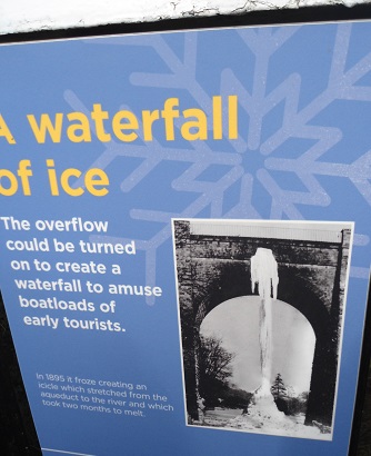
We looked at the information boards and were amazed to see a photo of an iced waterfall from an aqueduct to the river in the 1800s. It is a long time since we saw iced waterfalls in central Scotland.
Mining Bings
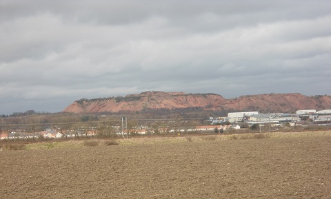
For many years when I travelled from Glasgow to Edinburgh by train I noticed a red hill in the distance which reminded me of Uluru/Ayers Rock in Australia although I have never actually been there. The largest and highest of the distinctive pink-coloured oil shale bings of the area is Greendykes Bing which lies near Broxburn and has a footprint of 82 acres. Its top forms a significant grass-covered plateau which reaches a height of 606 feet above sea level, or 311 feet above the surrounding landscape. Its steep slopes are remarkably stable, owing to the mixed size of the shale substrate, and the material is non-toxic, with none of the heavy metals or other toxins associated with coal-mine waste. We could see the bings in the distance during the walk.
The oil shale industry was pioneered in 1858 in the local area by James ‘Paraffin’ Young (1811-83) which soon comprised 120 oil works extracting more than 22 million gallons of oil from 340 million tonnes of shale annually and employing up to 40,000 people. It was abandoned in 1925 – the bings were the resultant waste.
River Avon

We reached the River Avon after walking alongside the Union Canal and crossing the Aqueduct which is the second largest aqueduct in Britain and the largest in Scotland. It measures 810 feet long, 86 feet high and 24 feet wide. To reach our lunch stop at the picnic tables on the other side of the canal we descended to the River Avon by steps but on the return had to climb back up the 86 feet. It was then a walk back to the car park at Almondell for the drive back to Glasgow.
Many thanks to Bill for being such an interesting and knowledgeable leader.
Before the pandemic lockdown I managed one more walk from Renton to Balloch and I will write about it next month.
Contact me at helenrose52@hotmail.com
This section: Helen Rose Hillwalking Diary, Pat's Home Page Blog
Filed under: Helen Rose Hillwalking Diary, Pat's Home Page Blog
Prevous page or post | Next page or post
Written by : Helen Rose
![]() Scottish hill walker and writer for Pat's Guide to Glasgow West End.
Scottish hill walker and writer for Pat's Guide to Glasgow West End.
Related Pages
- Terry Neason Songs and Words, Òran Mór
- tell it slant at Locavore
- ‘Premature’: First clip released from brand new Scottish rom-com
- Commonwealth Community Festival
- Alasdair Gray Archive – Matthew Arthur Williams: Holding Ground
- Wullie Davidson Bus Pass Rambles: Walk to Steall Falls in Glen Nevis
- Going for Gold: Young Talent 2026 at ProjectAbility
- Arepas for Venezuela – Fundraiser
- Take 2: Muppet Treasure Island at GFT
- Wildlife Watch at The Saltings: An Introduction to Wildlife Recording
- Exhibition Faifley Art Group
- Scottish Writers Centre Speakeasy The Griffin
- Watershed Festival at The Briggait
- Gaggle
- Glasgow Merchant City Festival 2026
- Partick Thistle F.C. Exhibition, Maryhill Burgh Halls
- Chicago! The Drag Along at OranMor
- Helen Rose Outdoor Diary: Elie Chain Walk.
- The Effect by Lucy Prebble at Cottiers
- Dementia Heroes – Family Carers Day