W. Davidson Climate Change Blog: Super El Nino on the Way?
On March 12, 2026, the US National Oceanic and Atmospheric Administration (NOAA) predicted that an El Nino was more likely than not to develop by midsummer. In its just released April ENSO outlook, the European Centre for Medium-range Weather Forecasts (ECMWF) was even more bullish. Every one of its 20 strong model ensemble members is predicting a moderate to strong El Nino by mid June. This is unusual, as strong El Ninos do not usually form until later in the year. For October, half of the the ECMWF models are predicting SSTs in the main El Nino region to exceed +2.5 C, which would make it a ‘Super’ El Nino. It’s worth bearing in mind that spring El Nino predictions are less reliable than ones made later in the year.
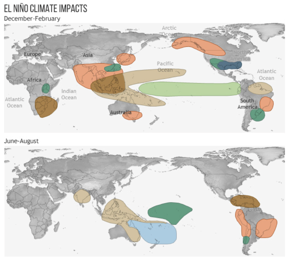
The El Nino Southern Oscillation (ENSO)
The El Nino Southern Oscillation (ENSO) is a non regular periodic warming or cooling of equatorial Pacific Ocean sea surface temperatures (SSTs), which can have significant effects on global temperature, and on regional droughts and floods. There are three phases – ENSO neutral, El Nino and La Nina. ENSO neutral is when SSTs are within plus or minus 0.5 C of the average. El Ninos are declared when SSTs exceed 0.5C above average for at least 3 months, and La Ninas when SSTs are at least 0.5 C below average for 3 months. El Ninos warm the planet and La Ninas cool it.
El Nino Termperatures (weak, moderate, strong and very strong
+0.5 to +1.0 C is a weak El Nino, +1.0 to +1.5 C moderate, +1.5 to +2.0 C strong, and above +2.0 C is very strong. The temperature anomaly only rarely exceeds +2.5 C, and when it does, it is often referred to as a ‘super El Nino’. Since 1950, the only El Ninos to have exceeded +2.0 C for a minimum of three months were in 1972-73, 1982-83, 1997-98, 2015-16 and 2023-24. The strongest of these was the 2015-16 event, which pushed past +2.5 C. 2023-24 also exceeded +2.5 C, but for less than 3 months.
El Ninos usually begin in the second half of a year, and persist well into the following year. Even moderate events result in global temperature records, but the record breaking can be quite spectacular, by as much as 0.3 C, in very strong events. Global temperature records will be broken in the first year, and broken by an even greater margin in the second year.
Global annual temperature anomalies relative to the average for 1951-80 (NASA /GISS).
2012 +0.64 C
2013 +0.67 C
2014 +0.75 C
2015 +0.89 C ‘Super’ El Nino
2016 +1.01 C ‘Super’ El Nino
2020 +1.01 C weak to moderate El Nino
2021 +0.85 C
2022 +0.89 C
2023 +1.17 C very strong El Nino
2024 +1.28 C very strong El Nino
Polar Jet Stream
The polar jet stream has a profound effect on northern temperate latitude weather. It travels west to east, with large wave like features, called ‘Rossby waves’. It is caused by a combination of the Earth’s rotation, and the temperature contrast between Arctic and temperate latitude air masses. Global warming has caused the Arctic to warm more than the sub-Arctic, so the temperature contrast has diminished. As a result, its west to east movement has slowed down, and its giant waves have become even larger, and plunging further south. This means that weather events associated with the jet stream have become longer lasting and more likely to affect southern regions. Earlier this year, Spain and Portugal bore the brunt of a slew of jet stream induced storms, as did Cornwall.
Heat Domes
‘Heat domes’ are another weather phenomenon that appear to be becoming more common due to changes in the jet stream. A heat dome is caused by a persistent, strong high pressure system that parks over a region, acting like a lid on a pot. This set up causes sinking air to compress and heat up, trapping hot air underneath, so that it doesn’t rise and disperse in the way that warm air usually does. At the same time, clouds and cold fronts are prevented from entering by the pressure, leading to a self reinforcing cycle of extreme temperatures.
In late June and early July 2021, an extraordinarily strong heat dome in Oregon, Washington state and British Columbia, Canada, was responsible for record high temperatures. Lytton, British Columbia, set a Canadian national heat record on three consecutive days, hitting a peak of 49.6 C (121 F) on June 29. This obliterated the previous record by almost 5 C, as clear a signal as you could get that the past is no longer a reliable indicator in our rapidly changing world. On June 30, Lytton was destroyed in a wildfire.
According to the NOAA, March 2026 tied with 2024 as the second warmest March, globally, in a dataset going back to 1850. In the US, March was the warmest March on record, by a large margin, due to a persistent heat dome in the south west. 43.3 C (110 F) was recorded in Arizona, the highest US March temperature on record. Several states recorded temperatures that even surpassed their record high temperature for April. It’s possible that heat domes and the extreme temperatures associated with them will become more common in western North America. It’s a worrying development, and one that wasn’t foreseen by climate scientists. The nationally averaged US precipitation total for January to March was the lowest on record, at 4.79 inches. The previous record low for the period was 5.27 inches in 1910.Most of the country is in severe drought, and this may presage an above average number of wildfires.
Record Low Arctic Ocean Sea Ice Area
Arctic sea ice reached its maximum extent for the year on March 15, 14.29 million square km (5.52 million square miles), tying with 2025 for the lowest maximum in the 48 year satellite record. This was 1.3 million square km less than the average for the1981-2020 period. March Arctic Ocean ice extent is declining by around 2.5% a year.
Wullie Davidson, April, 2026
(Photo attribution: attribution:
Content published by Rebecca Lindsey and reviewed by Tom Di Liberto. Image credit to NOAA Climate.gov, Public domain, vi)
This section: Pat's Home Page Blog, Science: Climate Change and Other Topics
Filed under: Pat's Home Page Blog, Science: Climate Change and Other Topics
Prevous page or post | Next page or post
Written by : Pat Byrne
Publisher of Pat's Guide to Glasgow West End; the community guide to the West End of Glasgow. Fiction and non-fiction writer.
Related Pages
- Alasdair Gray Archive – Matthew Arthur Williams: Holding Ground
- Wullie Davidson Bus Pass Rambles: Walk to Steall Falls in Glen Nevis
- Going for Gold: Young Talent 2026 at ProjectAbility
- Arepas for Venezuela – Fundraiser
- Take 2: Muppet Treasure Island at GFT
- Wildlife Watch at The Saltings: An Introduction to Wildlife Recording
- Exhibition Faifley Art Group
- Scottish Writers Centre Speakeasy The Griffin
- Watershed Festival at The Briggait
- Gaggle
- Glasgow Merchant City Festival 2026
- Partick Thistle F.C. Exhibition, Maryhill Burgh Halls
- Chicago! The Drag Along at OranMor
- Helen Rose Outdoor Diary: Elie Chain Walk.
- The Effect by Lucy Prebble at Cottiers
- Dementia Heroes – Family Carers Day
- Take 2: Arco (Dubbed) at GFT
- An Tír úd Thoir : Immigrants from Donegal to Glasgow share their stories
- Heritage Talks Kelvin Hall at WestFest
- WESTFEST Presents ROBOTS AND ORANGES WITH ALAN WINDRAM