Helen Rose’s Outdoor Diary: Raasay
Raasay – November, 2022
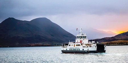
Raasay is an island off the coast of the Isle of Skye in the Inner Hebrides in North West Scotland. Skye is connected to the mainland by a bridge and travel to Raasay is by a short ferry journey from Sconser on Skye. There is a new ferry called the MV Hallaig; it’s a diesel-electric hybrid. She was the first ship to be fully built and delivered on the River Clyde near Glasgow in over five years and one of two hybrid ferries to combine diesel electric and lithium-ion battery power. She is named after a poem by Sorley MacLean.
Additionally, should you choose to explore Raasay, you will be tredding in the footsteps of Boswell and Johnston who visited Raasay House in the 1770s and wrote, “We found nothing but civility, elegance and plenty”; it is not only the impressive mountains of Skye that are attractive! Skye is famous for the Cuillin Mountains, which I climbed in my Munro bagging days. In 1773 Samuel Johnson and James Boswell made their celebrated journey through the Highlands of Scotland and the Hebrides. Johnson published his great account, “Journey to the Western Isles of Scotland” in 1775, and it became one of the most popular social commentaries of its age.
Inverarnish

Inverarnish is the main village in Raasay – it has a community shop and post office. There’s a very close knit community of 160 on the island and the shop is run by the community. It was good to see the local initiative with the duck eggs for sale from a caravan. The island is dependent on the ferry for delivery of supplies. Raasay is the same land mass as Manhattan which has a population of 1.6 million compared to 160 on Raasay!
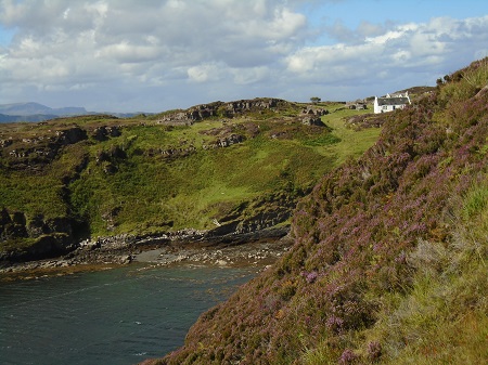
Raasay House
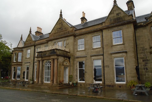
We stayed in Raasay House, the only hotel on the island. It dates from the early 1500s and was built as the Macleods of Raasay Clan Chief’s House but was burnt down in 1746 after the Battle of Culloden. It was later derelict until the present owners restored it as a hotel and Outdoor Centre. In 1773 when Dr Samuel Johnson and James Boswell made their historic journey to the Western Isles, and were guests of the Macleod chief of Raasay, they stayed at Raasay House.
There is a good view of Skye from the house.
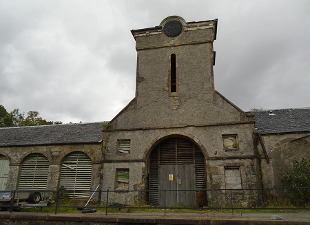
There is an interesting clock tower in the grounds where it is said that the clock stopped when the men of the island went to fight in the First World War.
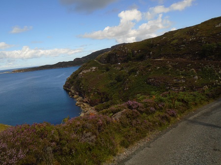
Hallaig
On our first afternoon we walked to Hallaig to see Sorley MacLean’s memorial. The walk had excellent views over to Applecross on the mainland. Hallaig is the most recognised poem of Sorley MacLean, an important Scottish poet of the 20th century. After writing the poem, MacLean rose to fame in the English-speaking world. It was originally written in Scottish Gaelic since the author was born on the island of Raasay, where Scottish Gaelic was the everyday language.
Brochel Castle
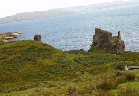
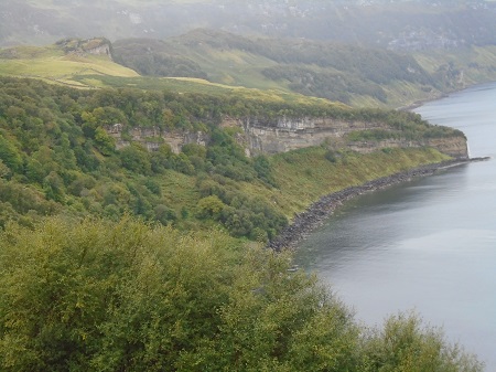
On the second day we were in the north east of the island and admired the ruins of Brochel Castle a late 15th/early 16th century occupied until c.1671. It was an impregnable stronghold and an ingenious fusion of natural rock and masonry rising sheer from a stack-like volcanic plug some 15 metres high. Built, so the favoured tradition goes, by Raasay’s first Macleod chief, Calum (MacGilleChaluim), it provided a strategic base for a dynasty of reiving seadogs to control their mainland possessions and the Inner Sound. Even today, with masonry eroded to precarious stumps; it is easy to see why Brochel has often been depicted as something born of realms fantastical. Though only footings survive of the tallest tower, which rose to corbelled battlements (Daniell’s view of 1818 depicts it virtually intact), remnants of three other tower structures on different levels still conjure up a thrilling spectacle. Entrance was via a steep ridge leading up from the east to a narrow cleft between projections of rock and masonry, with sheer drops on the other sides.
Calum’s Road
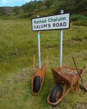
Calum was the son of Donald Macleod of Arnish and Julia Gillies of Fladda. Calum and his brother, Charles, constructed the track from Torran to Fladda over three winters from 1949 to 1952. For this, they were each paid £35 a year by the local council.
After decades of unsuccessful campaigning by the inhabitants of the north end of Raasay for a road, and several failed grant applications, Calum decided to build the road himself. Purchasing Thomas Aitken’s manual Road Making & Maintenance: A Practical Treatise for Engineers, Surveyors and Others (London, 1900), for half a crown, he started work, replacing the old narrow footpath. Over a period of about ten years (1964–1974), he constructed 13⁄4 miles (2.8 kilometres) of road between Brochel Castle and Arnish, using little more than a shovel, a pick and a wheelbarrow. Initial blasting work was carried out and funded, to the sum of £1,900, by the Department of Agriculture’s Engineering Department, who supplied a compressor, explosives, driller, blaster, and men.
Several years after its completion, the road was finally adopted and surfaced by the local council.
Torran and Fladday
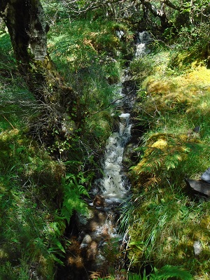
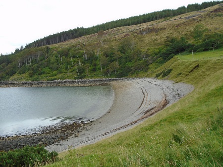
At the end of Calum’s Road in Arnish, we walked towards Fladday, an island off Raasay joined by a causeway at low tide. On the way we passed the hamlet of Torran with a lovely waterfall.
Fladday is across Caol Fladday but we could not cross to it as it was high tide. Once a thriving crofting community, the island now only has three cottages which are used by the families who own them for about seven months a year. We did a circular walk inland over the moors and reached Torran to make our way back to Arnish.
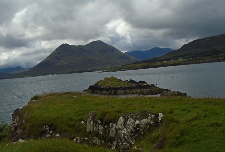
Dun Caan
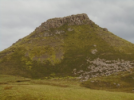
Dun Caan is the highest point on the Isle of Raasay, a very distinctive flat-topped summit, volcanic in origin. It is a superb viewpoint – so good that early visitor James Boswell danced a jig of delight on the top. We started the walk on a good path but eventually we saw the path had a steep descent on an eroded path before a walk to the final summit. There was some concern in our group about this path so we descended in to the glen. There is no mention of the difficult terrain on the walk descriptions available. The glen was very boggy as there had been recent heavy rain but we bravely walked on to find a better path!
Mines
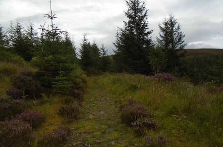
The path continued onto the Burma Road, so called as a reference to its construction by forestry workers in the 1950’s and the “jungle” of trees they encountered! It continued through the forest to Mine 1. The mines on the island were for Iron Ore. It may be surprising to learn that iron ore bearing jurassic rocks was found in such a remote part of the Hebrides on an incredibly beautiful Island.
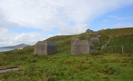
The mines that were dug here were worked mainly during the First World War period by German prisoners of war employed for that purpose. The mineral diatomite (known locally as ‘Cailc’ – Gaelic for chalk) was extracted, kiln dried, ground and calcined on site to eventually be used to create dynamite for military purposes. A row of ruined former workshops and offices lie open to the elements, as are the remains of the one-time power house.
Distillery
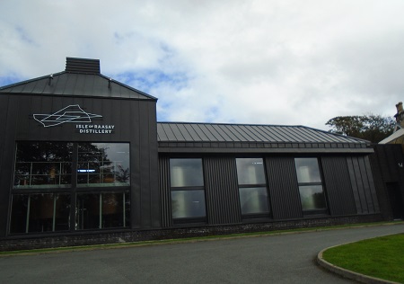
There is a distillery on the island and rooted in centuries of illicit distilling. Raasay provides the ingredients for the perfect dram. At Raasay Distillery every drop of spirit is distilled, matured and bottled using local water from the island.
For an island the size of Raasay with a small population there are a small number of churches. Had we had rime we would have visited the 13th century ruins of St Maol-luag, called after an Irish monk, and the Pictish Stone. It is said that the Raasay Pictish Stone was found by James MacLeod of Raasay in about 1800. It was unearthed not far from the harbour at Clachan on the course of an access road he was building to his Raasay House.
It has to be ‘Haste Ye Back’ to an island with so much to explore.
Thanks to Ian Lamb for information on mines and photo.
Coming attraction; Kincraig
This section: Helen Rose Hillwalking Diary, Walks
Filed under: Helen Rose Hillwalking Diary, Walks
Prevous page or post | Next page or post
Written by : Helen Rose
![]() Scottish hill walker and writer for Pat's Guide to Glasgow West End.
Scottish hill walker and writer for Pat's Guide to Glasgow West End.
Related Pages
- Helen Rose Outdoor Diary: Elie Chain Walk.
- Helen Rose Outdoor Diary: Aviemore Again.
- Helen Rose Outdoor Diary, Fairlie
- Helen Rose Outdoor Diary: Cairneyhill to North Queensferry
- Bob Law: Heads of Ayr to Dunure Coastal Walk
- Helen Rose Outdoor Diary: Busby to Eaglesham
- Helen Rose’s Outdoor Diary: Roman Barr Hill and Croy Hill.
- Ayrshire Coastal Path. Final Sections. November 2025
- Helen Rose’s Outdoor Diary: Glasgow Cathedral and Necropolis
- Helen Rose’s Outdoor Diary: Royal Edinburgh Military Tattoo
- Helen Rose’s Outdoor Diary, Alnmouth, Northumberland
- Helen Rose’s Outdoor Diary: Braemar
- Glasgow Botanic Gardens – Tour the Kibble Palace
- Helen Rose Outdoor Diary: Robert Burns Country
- Helen Rose’s Outdoor Diary: Cademuir, Peebles.
- Aviemore – Helen Rose Outdoors
- Helen Rose’s Outdoor Diary: El Rompido Part 2.
- Helen Rose’s Outdoor Diary, El Rompido Part 1.
- Helen Rose Outdoors – Grantown on Spey.
- Helen Rose’s Outdoor Diary: Edinburgh.