


A Circular Cycle/Walk from Kelvingrove Park
The West End (and thereabouts) is a great place for a walk around and there are also some interesting cycle routes. Ian Mitchell, local Westender, writer, historian and fan of the great outdoors, has provided information which will interest those of you who like to get out and about and really stretch your legs:
A Circular Cycle/Walk from Kelvingrove Park.
The pressure generated for the creation of designated cycle tracks in Scotland is, to a large extent, the work of Sustrans, a charity which has negotated, promoted and built many miles of them in England, Wales and Scotland. Most of the tracks have been constructed on abandoned railways and canal paths, and there is a plentiful supply of both in the Glasgow region - several of which pass through the West End. (The centre of Glasgow is being connected to Kelvingrove Park by an extension of the Cycle Track network).
The biggest, and so far the best, cycle track is that from Glasgow to Loch Lomond and the first stage of the Glasgow-Edinburgh link is now open - between Bathgate and Airdrie. The existing routes are very enjoyable and not only do they take you away from the fumes and danger of cycling on roads congested by traffic, but because they also often take you deep into Glasgow's industrial history.
 Even before Sustrans had opened the Glasgow-Loch Lomond cycle track, I had discovered a route that did just that. By pedalling, or walking along the Kelvin Walkway and linking up with the Forth and Clyde Canal towpath at the Kelvin Aqueduct, it was possible to organise an outing with only one brief crossing of a public road.
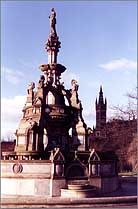
The first route starts in Kelvingrove Park, near the fountain erected by the grateful citizens of Glasgow to the man who brought them pure water in lead pipes from Loch Katrine, Provost Stewart. Sadly, the purity of the water means that unhealthy quantities of the lead can be found in the bodies of the city's inhabitants. The fountain dates from 1872 and can be viewed as a monument to error and the contradictions of progress.
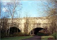 After crossing Kelvingrove Park, the route then leads under Kelvin Bridge, on past a ruined grain mill and behind the BBC Scotland headquarters in Queen Margaret Drive. Then, after flanking the Botanic Gardens, it emerges behind the old Maryhill Barracks, and soon arrives at Scotland's Pont du Gard, the Kelvin Aqueduct. A miracle of the 18th century engineering and architecture, this was in its day the largest functioning aqueduct in Europe, and a major tourist attraction. It practically bankrupted the Forth and Clyde Canal Company, and held up work for seven years. it is 400 ft long and stands 75 ft high on four graceful arches, the masterpiece of the engineer Robert Whitworth, who, replaced John Smeaton as chief engineer on the canal.
A pech uphill to join the canal bank from the walkway, shows the Kelvin Dock, where many of the canal's boats were built. The tow path eases the journey to Clydebank. Along the canal went the grain, iron ore and textiles of the first phase of Scotland's industrial revolution.. Heavy engineering replaced textiles as Glasgow's main industry, and the Clyde replaced the canal as the city's main link with the world.
Safe and fee from traffic, this route shows the post-industrial city as a nature reserve. both tow-path and walkway are fringed thickly with trees and shrubs, and I've seen herons fishing behind BBC Scotland headquarters, watched squirrels at Kelvindale and disturbed a fox at Westerton. In spring the canal is the nesting place of swans and coots, in autumn the haunt of berry-pickers, and year round the beat of apparently luckless anglers, though I have seen the more favoured occasionally pull a stunted pike from the murky depths of the waters. And of course the more traditional Glasgow flora and fauna of old bedsteads, abandoned cars and drunks are also encountered. At the moment the canal is largely dried out and there is a lot of restoration work going on and all the rubbish is being thankfully cleared away.
Although not an "official" cycle track, the artery of Scotland's first industrial revolution is widely used by cyclists, and it joins the official Glasgow to Loch Lomond cycle track at Clydebank Shopping Centre. By combining the two routes in either direction, a round trip of about 14 miles gives a couple of hours' cycling or five hours walking.
This Glasgow to Loch Lomond track, which was opened in 1989, can be a bit difficult to track down, but access can be got from a subterranean passage beside the former Partick Fire Station, now converted into flats. The track follows the course of an old railway, and thus the gradients are always mild. This, with the tarred surface, makes it easy going. The views south across the Clyde, and north to Kilpatrick Hills are fine, but the cycle track is less vegetated than the canal path, and thus supports less wildlife, although I did once see a kestrel hovering over the track.
But for foot or pedal powered industrial archeologists, the track is a dream, a vantage point to the deindustrialisation of Glasgow. Amid the pockets of yuppification - the odd block of smart flats, a marina - are miles of abandoned shipyards, factories, dockyards, whose names read like a litany of Glasgow's lost greatness.
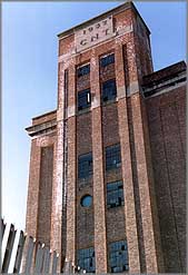 The Clyde Navigation Trust, whose huge satanic granary, the largest brick building in Glasgow, now lies empty, Barclay Curle's engine works, with German-influenced steel and glass frame and mansard roof and the site of Albion Motors, part-demolished. And now the cyclist dodges between those who worked - or probably, whose fathers worked - in the abandoned factories, walking their rotweillers and alsatians, drinking in quiet knots at 8a.m.
The Kelvin Walkway and the Forth and Clyde Canal towpath have attracted a wide variety of users, apart from cyclists. In addition to the legions of joggers, one can see climbers practising their arts on the Kelvin Bridge, and even occasionally canoeists shooting the Kelvin rapids.
Along with this usage has come the provision of decent watering places. You can stop for a pint of real ale at the Lock 27 on the canal at Anniesland, or have yourself a coffee and croissant at The Big Blue, under Kelvin Bridge.
No such establishments have as yet attached themselves to the cycle track, for apart from the cyclists, it is mainly used by the locals as a dog walking path, or as a route to their pigeon lofts. Nevertheless, since it takes you through a part of Glasgow that is by no means miles better, it should be visited by anyone who wants a completer picture of life there.
Those of you who are really fit and adventurous may want to carry on further- From Clydebank you can move back onto the towpath of the Forth and Clyde Canal and cycle past Old Kilpatrick, under the Erskine Bridge to Bowling and then Dumbarton. Once through Dumbarton, the route follows the banks of the Leven to Balloch and Loch Lomond. If you go this far it is reassuring to know that you can always get the train back to the Westend.
Ian Mitchell.
Details of cycle paths in Scotland can be obtained from Sustrans at 53 Cochrane Street, Glasgow G1 1HL. Telephone: 552 8241.
Copyright I.R. Mitchell
Read about Ian Mitchell
BECOME A MEMBER!
WHAT'S NEW.

Out and About
- What's On!
- What's New
- Gig Guide
- Eating Out
- Pub Guide
- Cinema
- Cinema - Reviews
- Galleries / Museums
- Buildings / History
- Lynne's Arts News
- Outdoors
Contact Pat if you would like to be featured or advertise on this site.
Want to be featured or advertise on this site? Contact features or advertise.