Helen Rose Outdoor Diary: Kilpatricks. January 2021
Happy New Year!
As lockdown continues due to the Covid 19 Virus, I am still keen to do weekly walks as being out in the fresh air is good for the mind and body. This walk in the Kilpatrick Hills, near Glasgow, was with the walking club Glasgow HF outdoors The Kilpatrick Hills are a range of hills in central Scotland, stretching from Dumbarton in the west to Strathblane in the east. Strathblane divides the Kilpatricks from the Campsie Fells to the east, while to the north lies Loch Lomond and the Trossachs National Park. The circular walk started at Overtoun House where there are ample parking facilities.
Overtoun House
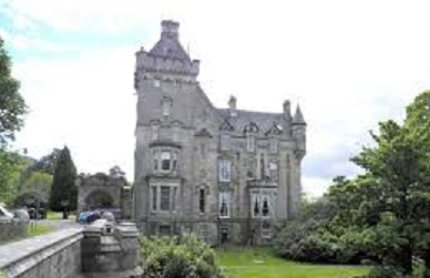
Overtoun House is a beautiful 19th-century country house designed in the Scottish Baronial Revival style and based on the Queens Balmoral Castle as part of a Gothic revival in Architecture. The estate includes paths and trails, one of which goes all the way into Dumbarton. Another one of the trails takes you down towards the river and underneath the bridge for pretty views of the house and bridge.
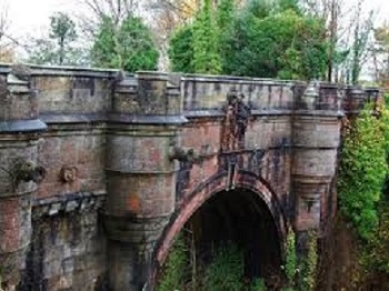
The bridge is known for a weird phenomenon that is claimed to drive canines crazy and has them leap to their death on the jagged rocks below in the Overtoun Burn. It is thought that the bridge is haunted or it could simply be the mink smell. As I don’t know what minks smell like, I cannot confirm why the dogs allegedly jump. Strange country myth though!
Overtoun House was built in 1862 by the wealthy Glasgow industrialist James White from Rutherglen. Today the house is home to a Centre for Hope and Healing with a tearoom serving snacks, hot and cold drinks and home baked cakes. I have had afternoon tea here in the past in the ornate drawing room and can highly recommend the cakes. (The History of Overtoun House)
We parked at the house to start the circular walk.
Black Linn Reservoir
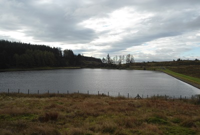
We walked on a good track, socially distanced of course, to make our way uphill to Black Linn Reservoir. The reservoir was built in the late 19th century. An Act of Parliament in 1857 empowered Dumbarton Town Council to take water from the Overtoun Burn for the town’s water supply but demand exceeded supply with an increased population which resulted in the Black Linn scheme to build the reservoir. The Black Linn waterfall on the west side of the reservoir gave its name to the reservoir. Walking alongside the reservoir, we saw some fishermen. Apparently, Northern Pike, Brown Trout, Australian Bass and even Atlantic Salmon have been caught in the reservoir. Leaving the reservoir, we walked on towards Doughnot Hill stopping on the way for our picnic refreshments.
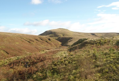
Doughnot Hill
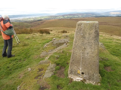
Like many other hills in the area, Doughnot Hill originated as a volcanic vent. An igneous dyke runs through the hill’s north-western slopes. There is a trig point at 1237 feet on the summit. The name Doughnot Hill is given on OS maps from the first edition (1860) onwards. It also appears, with the same spelling, on the even earlier “Plan of Dumbarton Muir” (undated, but made in the early nineteenth century). It is likely that the name was originally pronounced ‘dɔxnət’ or similar. The Doughnot Burn winds anticlockwise around the northern side of the hill before flowing into the Overtoun Burn. There are panoramic views down to the Clyde and built up areas and all around to the Campsie Fells. We descended on the rough moorland to the lower slopes to make our way to the Lang Craigs.
Lang Craigs
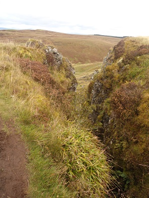
Lang Craig is probably from the Scottish words meaning long and rock. Lang Craigs is a mix of ancient woodland, sheltered glens, jagged outcrops, newer plantations and rugged moorland and lies at the foot of the spectacular Kilpatrick Hills and is owned and managed by the Woodland Trust.
The website gives lots of information on wildlife, walks and flora and fauna. There is also historical information on the acquisition of the estate and the woodland planting.
The Lang Craigs themselves were formed from volcanic lava 360 million years ago and cut away by the glaciers of the ice ages. Important fossils have been found near the site and it’s possible that there are also fossils to be found at Lang Craigs. The site also holds evidence of prehistoric human inhabitants including early enclosures and a carved stone.
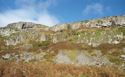
We walked up to the Craigs on a well-defined path. At this point we could not see the Craigs which are steep cliffs as we were starting to walk along the top of them. We stopped alongside the path for our picnic lunch with views over the patchwork farmland, moorland and woodland to the River Clyde and down to Dumbarton Rock. After lunch, we continued the walk along the top of the cliffs with some breath-taking glimpses down the rock face to the trees and shrubs determinedly growing out of the nooks and crannies. The path finally weaves its way down to farmland and we walked under the Craigs over the moorland and in to the woods by the burn and back to our starting point at Overtoun House.
A lovely day out with varied scenery, spectacular rock face and good company as always on these walks. Thanks to Jim for organising the walk and Kathleen and Jo for leading it. The paths on the estate are all good and the ascents are very gradual so very easy walking.
Coming attractions; North Calder Heritage Trail, Blantyre Circuit and possibly more Glasgow Parks if the severe lockdown due to the virus persists.
This section: Helen Rose Hillwalking Diary, Pat's Home Page Blog
Filed under: Helen Rose Hillwalking Diary, Pat's Home Page Blog
Prevous page or post | Next page or post
Written by : Helen Rose
![]() Scottish hill walker and writer for Pat's Guide to Glasgow West End.
Scottish hill walker and writer for Pat's Guide to Glasgow West End.
Related Pages
- Bangla Mela, Celebrating Commonwealth Games 2026
- Overhaul Live in Store, LNFG
- All Elements Scottish Hip Hop Jam 2026
- Terry Neason Songs and Words, Òran Mór
- tell it slant at Locavore
- ‘Premature’: First clip released from brand new Scottish rom-com
- Commonwealth Community Festival
- Alasdair Gray Archive – Matthew Arthur Williams: Holding Ground
- Wullie Davidson Bus Pass Rambles: Walk to Steall Falls in Glen Nevis
- Going for Gold: Young Talent 2026 at ProjectAbility
- Arepas for Venezuela – Fundraiser
- Take 2: Muppet Treasure Island at GFT
- Wildlife Watch at The Saltings: An Introduction to Wildlife Recording
- Exhibition Faifley Art Group
- Scottish Writers Centre Speakeasy The Griffin
- Watershed Festival at The Briggait
- Gaggle
- Glasgow Merchant City Festival 2026
- Partick Thistle F.C. Exhibition, Maryhill Burgh Halls
- Chicago! The Drag Along at OranMor