Harris. July 2019

Helen Rose Outdoor Diary.
Outer Hebrides.
The last time I went to Harris was ten years ago and I decided it was my favourite island in the Outer Hebrides of Scotland. Situated on Europe’s Atlantic edge, the Scottish Western Isles of the Outer Hebrides are a diverse chain of inter-connected islands with their own unique way of life. Harris is not an island on its own as North Harris is south of Lewis and connected by an isthmus to South Harris. At the isthmus lies Tarbert where the ferry comes in from Uig in the north of the island of Skye with a journey of about 90 minutes. On my previous trip I had done low level walks but had not been able to climb Clisham, the highest hill in the Hebrides or go to St Kilda, the most westerly point of Great Britain. Sadly, I was thwarted again on the St Kilda trip as the forecast of high winds in the afternoon meant the boat was cancelled. The weekend was organised by Glasgow HF Outdoor Club.
Harris
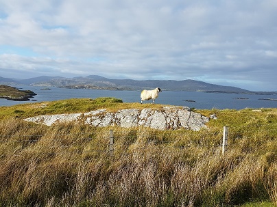
The islands of Scotland are very busy with tourists and accommodation is difficult to find. However, the club had booked the bunkhouse at 5 Drinashader which has a lovely location overlooking East Loch Tarbert. We had comfortable rooms over the two buildings and a fuel burning stove for cosy evenings in with a few wee drams and chat. The road to the bunkhouse is called The Golden Road as it was so expensive to build in 1946. Harris has a lunar landscape and Stanley Kubrick’s film 2001. Space Odyssey was partly filmed there in 1968. The alien planet surface seen as Dave Bowman passes through the Stargate are optically distorted shots of screen favourite Monument Valley on the Arizona/Utah border and the rocky coastline of South Harris.
Clisham
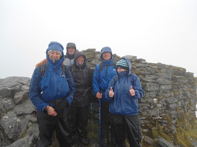
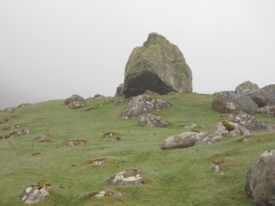
Clisham (Am Cliseam in Gaelic) is the highest peak in the Outer Hebrides at 2,621 feet and is located in North Harris. It is classed as a Corbett being a mountain of between 2,500 and 2,999 feet. We parked on the road and only had to climb 2,061 feet but it was uphill all the way from the start of the walk. Unfortunately, it rained constantly turning to heavier rain later and views were limited as the cloud base was low which made it difficult for navigating. We started on a good path but after crossing the burn it was not long until we were in the mist and the path was lost. We crossed several boulder fields of Gneiss rock which was not slippery and we even had a little scrambling. Eventually, we reached the summit ridge and picked up a path to the top where the Trig Point had a wall around it to shelter in for a quick lunch. We followed the good path all the way down but the compass and GPS were checked regularly to ensure the path went where we wanted to go. I can’t thank Jean and Sandra enough for staying with me on my very slow ascent and descent and I was able to tick Clisham off my Bucket List. We arrived back at the cars drookit (soaked through in Scottish slang) but happy!
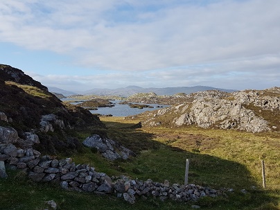
Huishinish
The next day was drier and the planned walk was from Huishinish on the west coast in north Harris. Much of the road was single track with passing places. The cattle also like to walk on the road and we were caught behind them so had no option but to wait until they spotted some grass they fancied and left the road so it was a slow motorcade behind the cattle. It was certainly rush hour but at a slow speed on Harris.
Huishinish is in the area of the North Harris Trust which is the community body managing the estate on behalf of the people of North Harris. It is stopping the downward economic spiral through various initiatives. It was a community buyout in 2003. The area includes beautiful beaches and our walk took us along a coastal path with views of other islands such as Scarp. These are not beaches for sunbathing and we were in full walking gear of waterproofs and boots. They are amazingly clean despite being washed by the Atlantic. We saw seabirds on the rocks such as Shags. Some of us did not complete the walk around the peninsula but opted to return to Huishinish Beach to relax. We met some brave young people who had gone for a swim but they did say it was very cold.
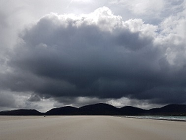
Luskentyre Beach
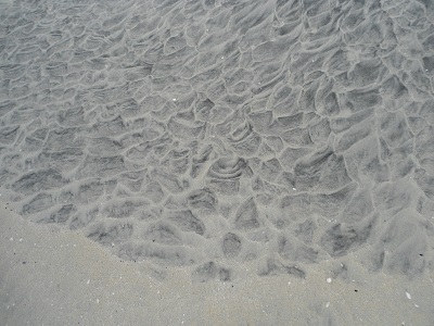
On the last day we had arranged the afternoon ferry and opted to spend time on Luskentyre Beach. Miles of pure white sand interspersed with rivulets. It’s all sugar sand, huge dunes and aquamarine water and is one of the best beaches in the world. There were strange patterns in the sand mainly caused by the wind but interesting designs. The clouds hanging over the beach were very dramatic. Later we returned to Tarbert to catch the ferry but first had a late lunch at the Harris Distillery. The way back to Skye on the ferry saw us sunbathing and admiring the clear views of the Cuillins in Skye. We stopped overlooking Loch Alsh to enjoy a picnic dinner as it is a six hour drive from Uig to Glasgow.
It was a magical weekend in good company on the wonderful Island of Harris and I will have to go back as it might be third time lucky to get to St. Kilda. https://www.kilda.org.uk/frame8.htm
Thanks to Paul for arranging the weekend.
Contact me at helenrose52@hotmail.com
Thanks to Monika Wastian for photos.
This section: Helen Rose Hillwalking Diary
Filed under: Helen Rose Hillwalking Diary
Prevous page or post | Next page or post
Written by : Helen Rose
![]() Scottish hill walker and writer for Pat's Guide to Glasgow West End.
Scottish hill walker and writer for Pat's Guide to Glasgow West End.
Related Pages
- Helen Rose Outdoor Diary: Elie Chain Walk.
- Helen Rose Outdoor Diary: Aviemore Again.
- Helen Rose Outdoor Diary, Fairlie
- Helen Rose Outdoor Diary: Cairneyhill to North Queensferry
- Helen Rose Outdoor Diary: Busby to Eaglesham
- Helen Rose’s Outdoor Diary: Roman Barr Hill and Croy Hill.
- Ayrshire Coastal Path. Final Sections. November 2025
- Helen Rose’s Outdoor Diary: Glasgow Cathedral and Necropolis
- Helen Rose’s Outdoor Diary: Royal Edinburgh Military Tattoo
- Helen Rose’s Outdoor Diary, Alnmouth, Northumberland
- Helen Rose’s Outdoor Diary: Braemar
- Helen Rose Outdoor Diary: Robert Burns Country
- Helen Rose’s Outdoor Diary: Cademuir, Peebles.
- Aviemore – Helen Rose Outdoors
- Helen Rose’s Outdoor Diary: El Rompido Part 2.
- Helen Rose’s Outdoor Diary, El Rompido Part 1.
- Helen Rose Outdoors – Grantown on Spey.
- Helen Rose’s Outdoor Diary: Edinburgh.
- Helen Rose’s Outdoor Diary – St Andrews from Kingsbarns
- Helen Rose’s Outdoor Diary: Kippford.