NORTH WOODSIDE: THE FORGOTTEN QUARTER
Ian R Mitchell strolls through an area of Glasgow that has seen hard times, but is now in better heart.
 Woodside is a place-name which is in danger of disappearing from Glasgow's geography. Urban redevelopments mean that people's concepts of what is meant by a particular area can expand -but they can wither as well. Nowadays North Woodside is generally regarded as part of Greater Maryhill, and the lower section of Maryhill Road certainly runs through it. But as a Woodside patriot put it to me in the local swimming baths one day, "London Road isnae in London, and Maryhill Road isnae in Maryhill." He has a valid point.
North Woodside has a very distinct geographical delineation, as clear and compact as a Parisian quartier. It straddles the triangle made by Maryhill Road (only re-named as such herabouts in the inter-war period) heading north from St George's Cross to Queen's Cross, where it turns south, occupying both sides of the Garscube Road till reaching what was formerly known as Garscube Cross, and then it re-connects with St George's Cross via the territories on either side of St George's Road. The former southern boundary, New City Road has all but disappeared under the M8 motorway.
The 1958 (Third) Statistical Account of Glasgow indicates North Woodside as a distinct entity, the city's smallest council ward by area (170 acres), and having at that time over 27,000 inhabitants. The SA also reveals the interesting fact that this amounted to the highest density of population in the city, at 158 persons to the acre greater even than that of the Gorbals. (The city average was 27). John Hume's Industrial Archeology of Glasgow gives a picture of local employment in Woodside in former days. At that time there was a great variety of industries in the area, almost all of them being small scale and many were highly polluting: chrome, bleach, iron factories being examples. Few areas benefited, or suffered, depending on your point of view, from Comprehensive Redevelopment as much as did North Woodside. The vast majority of the tenement buildings were demolished, and almost all of the industry was either re-located, or simply went out of business.
Nevertheless, 50 years on, the area retains its historical interest and this is represented by many fine public and some industrial buildings which survived redevelopment. These help to retain vestiges of a Woodside identity in what sometimes appears to be a losing battle with Maryhill expansionism. And though I don't live in the area, I live nearby and North Woodside has several attractions which frequently draw me there. Let's start our virtual tour- which I hope some will be encouraged to make a real tour- at the Front Line, the interface of North Woodside with Maryhill at Queen's Cross.
Although a forgotten quarter, North Woodside contains one of Glasgow's most visited monuments, the Rennie Mackintosh Queen's Cross Church. This, the headquarters of the Mackintosh Society was the only church the architect ever completed, and it is generally described as being in Maryhill. However when the church was built for the Free Kirk in 1899, this was Glasgow. The former burgh of Maryhill, later annexed by Glasgow , did not start until a couple of streets further north. It often saddens me a little that the thousands who come here on their Mackintosh pilgrimage never seem to venture further forth, and get a picture of the area and learn about the people Toshie built this church for - and there is plenty to see.
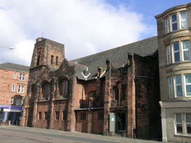 But before we leave, take a look around at the housing built here in the so-called Maryhill Corridor project in the 1980s and the later 1990s social housing constructed by Queen's Cross Housing Association. Whilst Comprehensive Redevelopment went too far in demolition and its own housing solutions were not always above criticism, there existed an undeniable problem of overcrowding and poor housing that had to be tackled. The housing conditions in this area were amongst the worst in Glasgow; look at what has replaced them without the starry eyed sterrheid nostalgia for yesteryear, and there is no doubt that things today are better than they were.
Partick Thistle F.C. are a strange - and welcome -non-sectarian phenomenon in a city dominated by the tribal loyalties of Rangers and Celtic. They are also strange in that they have not played in Partick- despite retaining the name- for over a century. People of a certain age may recall that when in the 50s the Hungarians were the most exciting team in the world, Partick were dubbed by those of an ironic disposition "The Mayhill Magyars". Wrong again, "They're nae in Partick, nor in Maryhill neither", according to my swimming-bath pundit cited earlier. Partick relocated here to Firhill Stadium, which is on the Glasgow - not Maryhill - side of the Forth and Clyde Canal. A short walk from the Mackintosh Church and we stand outside the pleasing stand built by The Thistle in 1927 - and sporting a thistle emblem. Perversity still brings me to Firhill occasionally, to watch what should be Woodside Thistle or the Woodside Magyars- though I accept these names don't have much ring.
Behind Firhill is a development of student flats, the proceeds from the building of which probably saved the club from liquidation, and the canal path which provides a grand belvedere over North Woodside, as we head down along the banks. Firhill Basin lies behind the stadium and here was a great concentration of canalside industry in former days. Excavated in 1799 and extended in 1849, the basin was the site of iron foundries, chemical works - and most importantly this was the centre of Glasgow's timber industry where the raw materials were brought by canal barge to the sawmills which cluttered the banks. Today the last vestiges of industry are gone, and whilst some land is being given over to housing developments, most of the area remains a wilderness, overgrown and filled with incredible wild life. On a fine day, with its view over the city, here is found one of the loveliest places in Glasgow.
On the north canal bank the wild land around Firhill Basin merges into Westercommon. This is also a wild and overgrown inner city habitat, which I have written about elsewhere,(Scots Magazine..........) and since it is across the canal in Possil, we will concentrate instead on what we can see from the North Woodside "proper", or south, canal bank. We look down on Garscube Road, or what remains of it after much demolition that is only slowly being infilled by new developments. Indeed all the housing on the north side of the road, "The Gaspipe" as it was known locally, is gone. The Gaspipe was North Woodside "improper", the roughest toughest place in the area, consisting of bad housing juxtaposed with polluting industries- a chrome works was situated amongst the housing, and an iron foundry. It was a violent area, an area of gangs and gangsters.
In his lovely book, The Scots-Italians, Joe Pieri writes of the Italian immigrants setting up fish and chip shops here in the early 20th century. The first location an Italian child learned was that of the local police station, and the first words taught were, "Big Fight in Fish Shop." But the Italians were not only the victims of this culture, some of their black sheep became mini-mafiosi themselves. Pieri tells of Tony Biagi, a street bookie and re-setter who was deported to Italy, and of Laurie Ventre, another who practised these trades but also had the reputation of paying the debts of needy local people. Pieri writes,
"His death in the 1960s was mourned in the Garscube Road by a funeral to rival that of any Chicago Godfather, with cartloads of flowers and hundreds of mourners who afterwards set new records for liquor consumed in local pubs."
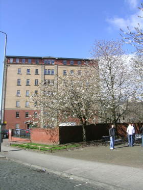 All along the Garscube Road are still gap sites and derelict land where once stood factories, like the sadly-demolished Great Canal Maltings, the biggest in the city. The Master Plan for the redevelopment of the Forth and Clyde Canal sees the regeneration of The Gaspipe in its restoration as a main thoroughfare, with new housing occupying the vacant land beside the canal. This would be a step forward, as at the moment the "landscaped" sites (as so often in inner cities) support only some spindly trees and much rubbish.
Woodside is an area of several fine churches, and looking across Garscube Road one comes into view which merits a short side trip. This is St Columba's R.C. Church built from 1937-41, and one of the first such commissions of the uncompromisingly modernist firm of Gillespie, Kidd and Coia. While Mackintosh's style looked backwards to Scottish vernacular, this firm embraced modernism and all its materials, such as concrete, with plain brick walls- inside and out. It contains a crucifix by Benno Schotz. The church which was expensive to build was reputedly paid for by local parishioners buying bricks at a half penny each.
The delightful Applecross or Possil Basin soon comes into view. This is the headquarters of British Waterways (Scotland) and usually hosts a varied flotilla of BW craft, tourist barges and other boats. The observant will notice that not only do many of the buildings date from the 1790s when the basin was constructed, but also that here the canal towpath is laid with rough cobblestones of that period. Dropping down Baird's Brae brings you to what was formerly Garscube Cross or what the locals call The Round Tower after one of the few buildings remaining in what is a rather untidy and incoherent area. The Tower looks like a tenement building but was actually constructed in 1875 as offices for a foundry and today contains a variety of small enterprises, sporting clubs and the like. It is not a great building but renovated it would help provide a feature in future redevelopment of the area. Until the 1950s one of its floors was given over to dancing as the Tower Ballroom.
Going down St George's Road things improve considerably and there is much to see. On our left (east) lies the North Woodside Estate constructed in the 1970s in bold brick medium-rise lines. This is a successful housing development with a real sense of community, as anyone visiting the Woodside Baths, which lie in the heart of the scheme, will find out. Ideas of inner city alienation can be overdone. When I started going to these baths, everyone knew everyone-except me. But I was soon accepted as a suitable recipient for the receipt of local punditry. The baths and washhouse were constructed in the 1880s when few here had washing facilities, and is the only building remaining from pre-1970. The baths were recently the subject of a massive renovation project .
On the other side of St George's Road are extensive housing developments from the 1960s, this time in the then fashionable high-rise mode. Re-clad in the 80s these are certainly striking, but at the moment the fate of such blocks is uncertain. My personal feeling is that there is too great a rush to demolish the high-rises, (as there was with the tenements) rather than to re-develop, and that we may live again to regret excessive thoughtless destruction. If the dominant form of middle class urban housing is now the high rise block, why isn't it - suitably funded - suitable for social housing? Why not ask those who live there? People have had enough of planners knowing best.
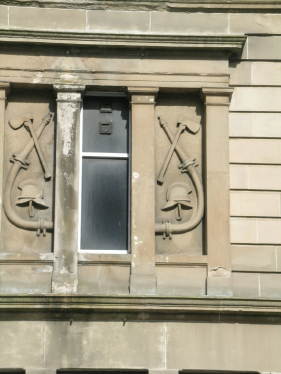
These two housing developments are welded together by St George's Road, which is a pleasing and interesting street. Most of the tenements are gone, many replaced by the new style of tenement buildings from the 80s onwards, but a couple of older ones remain. The most interesting is the housing block of the former Fire Station, a well built dwelling with large reliefs of the tools of the fireman's trade on the front. Next to it is St George's in the Fields, the last of Woodside's trio of fine ecclesiastical buildings. Built in 1885 by H & D Barclay this is one of Glasgow's finest High Victorian churches, with its Ionic portico and sculptured tympanum of Christ's loaves and fishes miracle. The church is now a housing development. But this does not exhaust the riches of this street, which many would be surprised to find in such a locale.
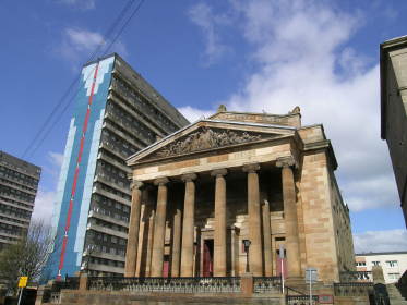
 A little southwards we come to a fine, isolated villa, complete with its own carriage- way and stable. This was one of a trio built in the 1830s as country houses for Glasgow businessmen, when here were open fields. The other villas went, though this jewel has survived, still used as housing. Indeed about 100 yards further on we come to Clarendon Place, surely one of Glasgow's finest "tenements" - though the word hardly applies to this colonnaded monument to architectural ambition. What on earth is this doing here? At the time of its construction in the late 1830s this was to be one of the two such buildings flanking the entrance to Great Western Road, Glasgow's most up-market street. As industry swamped the surrounding area, this plan was abandoned, leaving Clarendon Place in increasingly un-splendid isolation, surrounded by industry and slum developments. Thankfully it survived and is restored as an imposing sentinel at the Cross.
Before the Cross however, there is much more to see. In 1905 Andrew Carnegie gave Glasgow a large grant for books on condition that the Corporation built the libraries to house them. The architect J.H. Rhind got the contract and built six fine buildings to house the volumes, and one of them is the Woodside Library, sharing the features of the others Rhind built (Huge cupola for light penetration, symbolic sculptures representing Learning outside). The Library also contains an interesting small display about the history of the Woodside area, which is well worth looking at. One thing you can't look at any more - though there is material about it in the library exhibition - is the once-adjacent West end Playhouse, now demolished and replaced by modern flats. This was Woodside's Music Hall, with an extravagant Baroque interior, and French Second Empire exterior- architecturally eclectic as many such buildings were. Latterly it was operated as the Metropole Theatre by the late and well-loved Glasgwegian comedian and actor Jimmy Logan, before finally closing its doors in the 70s.
The Cross has another focal point in the impressive statue of St George and the Dragon, executed by Glasgow's best civil sculptors in the Victorian era, the firm of Mossman. This originally stood atop the local Co-operative buildings which stood across the road. Demolition led to its relocation to this small landscaped area. Clarendon Place takes us to Maryhill Road and to the many excellent housing developments from the 90s onwards which occupied areas that had been derelict eyesores for decades. In my view many of the houses here are equal architecturally to the best of the old tenement buildings -and they have better living facilities besides.
The dreaded word Maryhill may have been mentioned above, but we are still in Woodside, and any doubters should take a short walk to Glenfarg Street where the Council's Woodside Halls still function as a well used social centre. It is a cute wee building in red brick with stone dressing in a popular 1920s style that was dubbed "Wrenaissance". Opposite is another very tall building, now converted to housing, in a similar architectural style, and from the same period. This was built by the City Bakeries and was known for its good products and for its good industrial relations. Unlike most smallish employers here, the bakery recognised trades unions and was known for its hygienic working conditions and reasonable pay. One former employee recalls,
"The City Bakeries had the reputation for being a good employer to work for, because wages and conditions were good for those days. I got £3 a week. The management arranged social events, theatre evenings and a craft class. The factory was always clean and we were supplied with decent uniforms."
 This information comes from a collection of reminiscences which was made in the 1980s as Woodside's remaining industry almost vanished, entitled Working Lives in Woodside and North Kelvin 1900-60. Almost alone the bakery receives plaudits from its workers, most of whom mention low pay, unhealthy and dangerous work - with the constant threat of dismissal. The volume paints a picture of living and working in the Woodside area with an authenticity that it would be impossible for me to re-convey. (It can be consulted in Glasgow's Mitchell Library.)
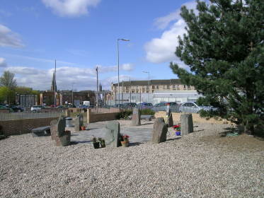
Continuing up Maryhill Road, at Hopehill road one is given the opportunity (if not taken earlier) to go and visit St. Columba's R.C. Church. But before doing so, it is a worthwhile experience to make a short stop at the Stockline Memorial Garden on the way. Most of Woodside's industry went, but some remained. In 2005 nine workers were killed at the Stockline Plastics factory here, after a massive explosion. Subsequent investigations found the owners guilty of breaches of health and safety regulations, and they were fined £400,000. Whether or not one thinks that that is a suitable sum for nine lives, a visit to the memorial garden is a moving experience, and possibly a fitting place to end a visit to an area well worth investigating.
Just avoid the word Maryhill and you will be welcome.


