


Loch Goil, Beinn Lochain
Helen Rose Hill Walking Diary September 2004
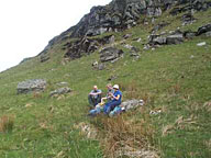
When I am hill walking, I sometimes like to combine it with some local history and visit new areas. This summer, Ralph led a walk for the Glasgow HF Outdoor Club to Beinn Lochain at Loch Goil where a USAAF B29 Superfortress crashed in 1949 killing all 20 of the crew on board. This site is unusual as most of the wreckage is on a small area including the fuselage, wings, undercarriage and various other pieces of wreckage. There is a memorial plaque to those who lost their lives in the crash and it is always sad to stand at a place like this. The ?plane crashed between the two hills of Stob na Beine Druim-fhinn and Beinn Tharsuin. and can be visited without actually climbing the hills. However, the main purpose for us intrepid hill walkers was to ascend the two peaks and also Beinn Lochain at the end of the ridge.
Loch Goil is located to the west of Arrochar and is reached by driving over the Rest and Be Thankful road to Loch Fyne then taking the minor road to Lochgoilhead. It is a pleasant drive of around 90 minutes from Glasgow. There was little in the way of paths on the walk but navigation was easy as it was a clear, warm, sunny day and Ralph had already ?reccied? the walk and planned the route carefully. It is a circular route which is always more interesting as the views are constantly changing throughout the day. The mountains form an escarpment overlooking Loch Goil.
 The first section of the walk was uphill through a fire break on fairly steep ground gaining access to a broad ridge where we stopped for coffee. I am renowned for insisting that I need an elevenses stop and have converted most of the HF members to having a proper sit down stop to enjoy the views. We needed to be fortified for the next section of the walk up a very steep gully but in no time we were on the summit of Stob na Beine Druim-fhinn. Now there is a mouthful of Gaelic. Does anyone know what it means?
 From the summit, we could see down to the crash site located near the trees. We had a walk around the crash site in the eerie silence before a further ascent to Beinn Tharsuinn where we had magnificent views over the Arrochar Alps to Ben Lomond in the distance. You will recall that I have previously written on the Arrochar Alps and I promise to write again about them in the near future. From there it was down to the col and up to Beinn Tharsuin, the highest point. This might all sound fairly easy but it is steep ascents on each of these three hills and the entire walk did take more than five hours. From the last hill it was down to Curra Lochain where Ralph had planned a stop for tea at the side of the Loch. Unfortunately, the midges were out in force and would have made a stop unbearable. The midges tend to hang around damp areas such as burns and lochs and in calm conditions they are eager to bite to reproduce and expand their population!.
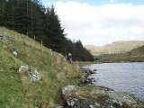 We continued the walk past the Sruth Ban Waterfall and onto the forestry track leading back to the start. Being deprived of our tea stop, we quickly made our way to the hotel at Lochgoilhead for the customary ?pint?, well deserved after a reasonably strenuous walk in the fresh air. It was a perfect day in glorious weather with great views and a bit of history. The company was also good!
Coming attractions; Munros at Loch Quoich, anything else I have done or that you request!
Contact me at [email protected]
Thanks to Ralph McLeod for the photos
Comments are now closed on this page
BECOME A MEMBER!
WHAT'S NEW.

Hillwalking Diary Archive
- Forth and Clyde Canal - 17th January, 2013
- Buttermere - 10th January, 2013.
- Barga, Tuscany - September, 2012
- West Highland Way - August, 2012
- Berwick on Tweed June 2012
- Malham, Yorkshire Dales May 2012
- Dean Castle Country Park April 2012
- Drama on the Cowal Way December 2011
- Newton Stewart November 2011
- Laggan October 2011
- Baltic September 2011
- Shetland Islands August 2011
- Falls of Glomach July 2011
- Colonsay and Oronsay June 2011
- Glencoe Celebration May 2011
- Hadrian's Wall February 2011
- Grey Mare's Tail January 2011
- Portpatrick December 2010
- Far North November 2010
- Creise and Meall a'Bhuiridh September 2010
- A Wild Weekend in Corrour! July 2010
- HW Family Walk May 2010
- Glen Finglas February 2010
- Corran and Ardgour January 2010
- Southern Outer Hebrides November 2009
- Lewis and Harris October 2009
- Magical Mull and Iona July 2009
- Easains May 2009
- Arran Again February 2009
- The Old Firm - November 2008
- Picos de Europa October 2008
- Mournes September 2008
- Far North Munros August 2008
- Greenland July 2008
- Ratagan June 2008
- Ben Dorain May 2008
- Carrbridge Weekend April 2008
- Gone to the Dogs January 2008
- Musical Legends December 2007
- Last Munro November 2007
- Bidein a'Choire Sheasgaich October 2007
- Sgurr na Ciche September 2007
- Maol Chean-dearg August 2007
- An Gearanach July 2007
- Glen Feshie June2007
- Island of Eigg April/ May 2007
- Island of Gigha March 2007
- Xmas in Perthshire February 2007
- Mullardochs, January 2007
- Altbeithe, Glen Affric December 2006
- Beinn Fhionnlaidh November 2006
- Cona Mheall October 2006
- Cairngorms Completed September 2006
- Seana Bhraigh August 2006
- Tarf Hotel Bothy July 2006
- Fisherfields June 2006
- Glen Dessary May 2006
- Serellas, Spain April 2006
- Glasgow March 2006
- New York February 2006
- Winter Dolomites January 2006
- Hong Kong December 2005
- John Buchan Way November 2005
- Navigation on Creag Pitridhs October 2005
- Fannaichs Finished September 2005
- Ben Alder August 2005
- Cuillins Completed July2005
- Meall Na Teanga, Water Aid June 2005
- Wales May 2005
- Krakow, Poland
- Glenfinnan Munros March 2005
- Monadh Liath February 2005
- Dunbar January 2005
- Loch Quoich Munros November/December 2004
- Fannaichs - October, 2004.
- Loch Goil, Beinn Lochain September 2004
- Floreana, Galapagos August 2004
- Lairig an Laoigh July 2004
- Sgurr nan Gillean June 2004
- Croagh Patrick, Ireland May 2004
- Cairngorms Revisited April 2004
- Lakes Again! March 2004
- Glencoe February 2004
- Pentlands January 2004
- Cairns December 2003
- English Lake District Return November 2003
- Last Munro October 2003.
- Hill Walking Diary: Strathfarrar - September, 2003
- Hill Walking Diary - Norway - August, 2003
- Helen Rose, Hill Diary, July 2003. Skye. - 3rd July, 2003.
- Helen Rose Hill Diary: Slioch June 2003.
- Cairngorms May 2003.
- April 2003 - Japan
- March 2003 - Ben Lomond
- February 2003: Arrochar Alps
- Hadrian's Wall - January, 2003.
- December 2002: Cycling to Linlithgow - December, 2002.
- The Lake District - November 2002.
- Hillwalking in Glen Affricc - October, 2002.
- Hillwalking Diary September 2002 - Gaick Pass
- Ben Nevis (2nd August, 2002)
- Northern Ireland (30th June 2002)
- Helen Rose in Brazil. (8th June 2002)
- Helen Rose in Braemar 4th May, 2002.
- Helen Rose's Hill Diary - April, 2002: the Island of Rum.(4th April, 2002)
- Helen Rose on her holiday - Helen Rose visit to Vienna (14th Mar. 2002)
- Helen Rose's Hillwalking Diary. Ossian (13th Feb 2002)
- Helen Rose's Hillwalking Diary, Patagonia. January, 2002
- Mull December 2001
- Helen Rose's Hill Walking Diary - November, 2001Bernese Oberland, Switzerland. (4th November, 2001)
- Helen Rose's Hillwalking Diary - Yosemite October, 2001.
- The Scottish Mountain Weather September 2001
- Andalusia August, 2001
- Ullapool Weekend July 2001
- Machu Picchu - June, 2001
- Helen Rose's Hillwalking Diary - Villarica May, 2001
- Helen Rose's Hill Walking DiaryDiabetes - April, 2001.
- Hill Scrambles March, 2001
- Everest Base Camp Feb 2001
- St Cuthbert's Way Jan 2001
- Hill climbing diary by Helen Rose, Knoydart (11/11/2000)
- Islay, Jura and Ratagan (Oct 2000)
- Iceland (20 Sept, 2000)
- Arran (22 August, 2000)
- An Teallach, July 2000
- Irish Munros, June 2000
Want to be featured or advertise on this site? Contact features or advertise.