


Glasgow West End: Hill climbing diary by Helen Rose
 Since I started the Web site I have met lots of Westenders who love to take to the hills on a regular basis. Helen Rose is one such Westender and she has agreed to provide regular information on her hill climbing exploits:-
Welcome to my hill walking diary - Helen Rose.
First, I will introduce myself. My name is Helen Rose and I am a resident of the Westend and a friend of Pat's. I am a keen hill walker and I have almost completed half of the Munros in Scotland. Munros are mountains over 3000 feet ( about 915 m.). There are presently 284 Munros in Scotland.
Sir Hector Munro published the first tables of the 3000ft mountains of Scotland in 1891. He could not have foreseen the number of walkers who, a century later would be looking at his tables and using them as an inspiration for hill climbing activities. Who can blame us for wanting to spend leisure time in the mountains as the views can be wonderful and there is no better way to get to know Scotland while getting exercise and fresh air.
It is almost eight years since I started hillwalking and I am in no hurry to complete the round of the Munros. Many of them I have climbed several times and the atmosphere can be very different depending on weather conditions. Initially, I said I would not go out in winter or try anything which involved scrambling requiring the use of the hands on rock.. Needless to say, I am now out in all weathers with crampons and ice axe in snow and ice and fingernails cut short to scramble over narrow rocky ridges which can be exhilarating.
The advantage of living in the Westend of Glasgow is the proximity to the mountains we can travel to for a day climbing. Ben Lomond is only an hour by car from the Westend.
There are many mountains under 3000 feet which I also walk on regularly. Some people think it is a bit sad that Munro baggers are intent in ticking off Munros but it does provide a challenge and incentive to keep going out as it would be easy on a cold morning to stay in bed rather than get up and face the mountain.
Anyway , for this first instalment on my hill walking I am going to tell you about my trip to Southern Ireland to climb the ten Irish Munros. Don't worry, there will be plenty on Scotland in the next instalments. In May, five of us set out to conquer the Irish Munros . Sir Hector did not list them but the term Munro is used widely now to describe mountains over 3000 feet. We had a wonderful week walking, eating, drinking pints of Kilkenny and listening to live Irish music in real Irish pubs.
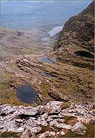
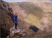
We travelled by car and used the catamaran from Stranraer to Belfast arriving in the Wicklow Hills at Glendalough in late afternoon. The area is near Dublin and there are ruins from early Christianity in the seventh century. The village is very pretty and the TV series Ballykissangel was filmed nearby. The next day we climbed a mountain called Lugnaquillia through a very pretty quiet valley with looming hills on either side. On to the ridge and into the mist where I thought that I would take a reading on my new GPS. We could not relate the reading to the map and after a lot of head scratching, we realised the GPS was set to British maps and had to be reset for Ireland. We reached the top and met some local people without a map who had come up a path from Fentons Pub. They said they never used maps and just got lost! There had been signs on the path but these had been removed to ensure walkers used maps. On our way down, we met 100 people coming up on a Charity fundraising walk.
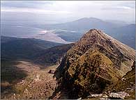
The following day we drove across Ireland to the Galtees which rise up from a flat plain This is very unlike Scotland where the views are always of mountains and it seemed interesting to us to sit on top of a mountain and look all around at a flat landscape. Before tackling the hill we found a little shop nearby to buy rolls and bacon and coffee. An important part of social hillwalking is to find good places for a second breakfast before actually starting the walk. We have got into very bad habits after hillwalking for so many years.
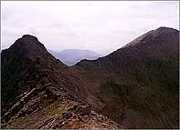
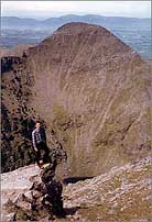
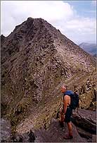
After the conquest of the Galtees, it was onward to Killarney and to Macgillycuddys Reeks to climb the range over two days. Unfortunately, the weather deteriorated but that did not deter your intrepid baggers who raced up 3000 feet to reach the very rocky Beenkeragh Ridge and bag the highest of the tops (Carrauntoohil) despite being battered by hailstones and having to slither over very wet rock. A long day but we deserved our pints of Kilkenny and plates of Irish stew at Kate Kearneys Cottage in the evening followed by the singing in the pub in Killarney.
The next day, the rain continued but nothing would stop us now from completing the Reeks. There were three rivers to cross which were swollen with all the heavy rain. I lack confidence in crossing rivers but the others managed to get me across and I am eternally grateful to them. At least they knew I would complete the circuit of the mountains as there was no way I would cross those rivers again! Up the gully appropriately called the Devils Ladder A9 it was long and steep on scree and water but we gained height quickly and were soon on the rocky scramble which was very exciting in parts. One of the tops was called 'The Big Gun' which is a wonderfully descriptive name for a huge slab of rock. Another conquest, an excuse for more beer and stew!
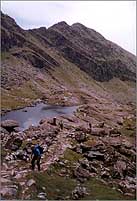
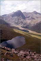
The last walking day was to Mount Brandon on the Dingle Peninsula.. It is regarded as a Holy Mountain and there is an annual pilgrimage where the pilgrims walk in bare feet. After passing the grotto, we walked through a very spectacular corrie with cliffs rising jaggedly and menacingly in nearly all directions to a steep path leading to the top. From the ridge we looked down on the chain of paternoster lakes. Unfortunately it was very cold, wet and windy on the top and we unrolled a flag and took some quick photos.